
Make a donation
Gear up for your next adventure:
As an Amazon Associate, this site earns from qualifying purchases at no extra cost to you.
Elst topographic map
Click on the map to display elevation.
Make a donation
Gear up for your next adventure:
As an Amazon Associate, this site earns from qualifying purchases at no extra cost to you.
About this map
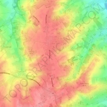
Name: Elst topographic map, elevation, terrain.
Location: Elst, Brakel, Oudenaarde, Oost-Vlaanderen, Vlaanderen, België (50.80860 3.71409 50.84355 3.75294)
Average elevation: 249 ft
Minimum elevation: 69 ft
Maximum elevation: 354 ft
Make a donation
Gear up for your next adventure:
As an Amazon Associate, this site earns from qualifying purchases at no extra cost to you.
Other topographic maps
Click on a map to view its topography, its elevation and its terrain.
Europawijk - Quartier de l'Europe
België > Oost-Vlaanderen > Oudenaarde > Ronse
Average elevation: 194 ft
Make a donation
Gear up for your next adventure:
As an Amazon Associate, this site earns from qualifying purchases at no extra cost to you.
Kerkem
België > Oost-Vlaanderen > Oudenaarde > Maarke-Kerkem > Maarke-Kerkem
Average elevation: 180 ft
Make a donation
Gear up for your next adventure:
As an Amazon Associate, this site earns from qualifying purchases at no extra cost to you.
Make a donation
Gear up for your next adventure:
As an Amazon Associate, this site earns from qualifying purchases at no extra cost to you.
Make a donation
Gear up for your next adventure:
As an Amazon Associate, this site earns from qualifying purchases at no extra cost to you.
Edelareberg
België > Oost-Vlaanderen > Oudenaarde > Oudenaarde
De Edelareberg of Kerselareberg is een heuvel met een hoogte van 86 meter in de Vlaamse Ardennen nabij Edelare (in de gemeente Oudenaarde). Op de top ligt het bedevaartsoord Kerselare met de Onze-Lieve-Vrouw van Kerselarekapel. Op de flanken liggen het Kezelfort en Villa Louisa.
Average elevation: 151 ft
Make a donation
Gear up for your next adventure:
As an Amazon Associate, this site earns from qualifying purchases at no extra cost to you.
Koppenbergbos-Zuid
België > Oost-Vlaanderen > Oudenaarde > Maarkedal
Het Koppenbergbos is hoofdzakelijk een beukenbos, heraangeplant na WO I als antwoord op de kaalslag tijdens het oorlogsgeweld. Stille getuigen hiervan zijn de loopgraven en vele bomkraters in het noordoostelijk deel van het bos. Verder groeien er ook eik, es, boskers en haagbeuk. In het zuidelijke deel van het…
Average elevation: 167 ft
Make a donation
Gear up for your next adventure:
As an Amazon Associate, this site earns from qualifying purchases at no extra cost to you.
Bos t'Ename
België > Oost-Vlaanderen > Oudenaarde > Oudenaarde > Mater
Het natuurhistorisch bosgebied ligt op de steile oostelijke flank van de Scheldevallei. Het reservaat bestaat uit bos, graslanden, poelen en ligt op een hoogte van 13 m tot 70 m.
Average elevation: 95 ft
Make a donation
Gear up for your next adventure:
As an Amazon Associate, this site earns from qualifying purchases at no extra cost to you.
Paterberg
België > Oost-Vlaanderen > Oudenaarde > Kluisbergen
In het wielrennen is de helling sinds 1986 vooral bekend door de wielerwedstrijd de Ronde van Vlaanderen. Samen met de Koppenberg en de Oude Kwaremont is de Paterberg een van de zwaarste hellingen van de wedstrijd en aldus ook een scherprechter. De Paterberg is een smalle kasseiweg met een gemiddeld…
Average elevation: 157 ft
Make a donation
Gear up for your next adventure:
As an Amazon Associate, this site earns from qualifying purchases at no extra cost to you.
Make a donation
Gear up for your next adventure:
As an Amazon Associate, this site earns from qualifying purchases at no extra cost to you.
Make a donation
Gear up for your next adventure:
As an Amazon Associate, this site earns from qualifying purchases at no extra cost to you.
Make a donation
Gear up for your next adventure:
As an Amazon Associate, this site earns from qualifying purchases at no extra cost to you.
Paterberg
België > Oost-Vlaanderen > Oudenaarde > Kluisbergen
In het wielrennen is de helling sinds 1986 vooral bekend door de wielerwedstrijd de Ronde van Vlaanderen. Samen met de Koppenberg en de Oude Kwaremont is de Paterberg een van de zwaarste hellingen van de wedstrijd en aldus ook een scherprechter. De Paterberg is een smalle kasseiweg met een gemiddeld…
Average elevation: 157 ft
Make a donation
Gear up for your next adventure:
As an Amazon Associate, this site earns from qualifying purchases at no extra cost to you.