
Make a donation
Gear up for your next adventure:
As an Amazon Associate, this site earns from qualifying purchases at no extra cost to you.
Oberaudorf topographic map
Click on the map to display elevation.
Make a donation
Gear up for your next adventure:
As an Amazon Associate, this site earns from qualifying purchases at no extra cost to you.
About this map
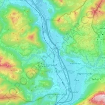
Name: Oberaudorf topographic map, elevation, terrain.
Location: Oberaudorf, Landkreis Rosenheim, Bayern, 83080, Deutschland (47.62456 12.02031 47.70137 12.20181)
Average elevation: 2,598 ft
Minimum elevation: 1,486 ft
Maximum elevation: 6,243 ft
Make a donation
Gear up for your next adventure:
As an Amazon Associate, this site earns from qualifying purchases at no extra cost to you.
Other topographic maps
Click on a map to view its topography, its elevation and its terrain.
Geigelstein
Deutschland > Bayern > Landkreis Rosenheim > Aschau im Chiemgau
1991 wurden große Flächen des Geigelstein als Naturschutzgebiet Geigelstein ausgewiesen. Das NSG Geigelstein hat eine Größe von 3135 Hektar und liegt zum Teil im Landkreis Rosenheim mit der Gemeinde Aschau sowie im Landkreis Traunstein mit der Gemeinde Schleching. Mit einem der größten Schutzgebiete auf…
Average elevation: 4,734 ft
Falkenstein
Deutschland > Bayern > Landkreis Rosenheim > Flintsbach am Inn
Average elevation: 2,014 ft
Make a donation
Gear up for your next adventure:
As an Amazon Associate, this site earns from qualifying purchases at no extra cost to you.
Kampenwand-Hauptgipfel
Deutschland > Bayern > Landkreis Rosenheim > Aschau im Chiemgau
Average elevation: 4,173 ft
Make a donation
Gear up for your next adventure:
As an Amazon Associate, this site earns from qualifying purchases at no extra cost to you.
Make a donation
Gear up for your next adventure:
As an Amazon Associate, this site earns from qualifying purchases at no extra cost to you.
Großhöhenrain
Deutschland > Bayern > Landkreis Rosenheim > Feldkirchen-Westerham
Average elevation: 1,864 ft
Make a donation
Gear up for your next adventure:
As an Amazon Associate, this site earns from qualifying purchases at no extra cost to you.
Make a donation
Gear up for your next adventure:
As an Amazon Associate, this site earns from qualifying purchases at no extra cost to you.
Make a donation
Gear up for your next adventure:
As an Amazon Associate, this site earns from qualifying purchases at no extra cost to you.
Hochrunstfilze
Deutschland > Bayern > Landkreis Rosenheim > Raubling > Nicklheim
Average elevation: 1,535 ft
Staffelstein
Deutschland > Bayern > Landkreis Rosenheim > Aschau im Chiemgau
Average elevation: 4,127 ft
Make a donation
Gear up for your next adventure:
As an Amazon Associate, this site earns from qualifying purchases at no extra cost to you.
Make a donation
Gear up for your next adventure:
As an Amazon Associate, this site earns from qualifying purchases at no extra cost to you.
Thalham
Deutschland > Bayern > Landkreis Rosenheim > Bruckmühl > Mittenkirchen
Average elevation: 1,765 ft
Bad Feilnbach
Deutschland > Bayern > Landkreis Rosenheim > Bad Feilnbach > Bad Feilnbach
Average elevation: 2,162 ft
Hohenaschau
Deutschland > Bayern > Landkreis Rosenheim
Aschach | Aschau im Chiemgau | Attich | Aufham | Außerkoy | Außerwald | Bach | Berg | Brückl | Bucha | Einfang | Engerndorf | Fellerer | Göttersberg | Grattenbach | Grenzhub | Grünwald | Hainbach | Haindorf | Hammerbach | Hintergschwendt | Hohenaschau im Chiemgau | Höhenberg | Hub | Huben | Innerkoy |…
Average elevation: 2,831 ft
Make a donation
Gear up for your next adventure:
As an Amazon Associate, this site earns from qualifying purchases at no extra cost to you.
Make a donation
Gear up for your next adventure:
As an Amazon Associate, this site earns from qualifying purchases at no extra cost to you.
Hochries
Deutschland > Bayern > Landkreis Rosenheim > Samerberg
Der Gipfel ist per Bahn von Grainbach aus zu erreichen. Vom Ort geht ein Sessellift zur Mittelstation auf 920 m Höhe. Von dort führt eine Kabinenbahn auf den Gipfel. Die Hochries ist als Rosenheimer „Hausberg“ beliebt bei Wanderern sowie insbesondere Gleitschirm- und Drachenfliegern.
Average elevation: 4,012 ft
Elend
Deutschland > Bayern > Landkreis Rosenheim > Wasserburg am Inn > Attel
Average elevation: 1,476 ft
Make a donation
Gear up for your next adventure:
As an Amazon Associate, this site earns from qualifying purchases at no extra cost to you.
Vagen
Deutschland > Bayern > Landkreis Rosenheim > Feldkirchen-Westerham
Vagen ist ein Ortsteil der Gemeinde Feldkirchen-Westerham im Landkreis Rosenheim. Das Pfarrdorf liegt auf einer Höhe von 525,7 m ü. NN. Vor der Gemeindegebietsreform 1972 war Vagen eine eigenständige Gemeinde.
Average elevation: 1,850 ft
Make a donation
Gear up for your next adventure:
As an Amazon Associate, this site earns from qualifying purchases at no extra cost to you.
Kleiner Traithen
Deutschland > Bayern > Landkreis Rosenheim > Kiefersfelden
Average elevation: 4,383 ft
Aich
Deutschland > Bayern > Landkreis Rosenheim > Raubling > Großholzhausen
Average elevation: 1,542 ft
Make a donation
Gear up for your next adventure:
As an Amazon Associate, this site earns from qualifying purchases at no extra cost to you.
Westerham
Deutschland > Bayern > Landkreis Rosenheim > Feldkirchen-Westerham
Average elevation: 1,909 ft
Hammerbach
Deutschland > Bayern > Landkreis Rosenheim > Aschau im Chiemgau
Average elevation: 2,858 ft
Make a donation
Gear up for your next adventure:
As an Amazon Associate, this site earns from qualifying purchases at no extra cost to you.
Unterlaus
Deutschland > Bayern > Landkreis Rosenheim > Feldkirchen-Westerham
Average elevation: 1,926 ft
Make a donation
Gear up for your next adventure:
As an Amazon Associate, this site earns from qualifying purchases at no extra cost to you.
Make a donation
Gear up for your next adventure:
As an Amazon Associate, this site earns from qualifying purchases at no extra cost to you.
Urschalling
Deutschland > Bayern > Landkreis Rosenheim > Prien am Chiemsee > Bach
Average elevation: 1,847 ft
Make a donation
Gear up for your next adventure:
As an Amazon Associate, this site earns from qualifying purchases at no extra cost to you.
Fachendorf
Deutschland > Bayern > Landkreis Rosenheim > Bad Aibling > Berbling
Average elevation: 1,729 ft
Make a donation
Gear up for your next adventure:
As an Amazon Associate, this site earns from qualifying purchases at no extra cost to you.
Kleinhöhenrain
Deutschland > Bayern > Landkreis Rosenheim > Feldkirchen-Westerham > Großhöhenrain
Average elevation: 1,841 ft
Stetten
Deutschland > Bayern > Landkreis Rosenheim > Prien am Chiemsee > Atzing
Average elevation: 1,913 ft
Make a donation
Gear up for your next adventure:
As an Amazon Associate, this site earns from qualifying purchases at no extra cost to you.
Feldolling
Deutschland > Bayern > Landkreis Rosenheim > Feldkirchen-Westerham
Average elevation: 1,837 ft
Make a donation
Gear up for your next adventure:
As an Amazon Associate, this site earns from qualifying purchases at no extra cost to you.
Make a donation
Gear up for your next adventure:
As an Amazon Associate, this site earns from qualifying purchases at no extra cost to you.
Happinger See
Deutschland > Bayern > Landkreis Rosenheim > Rosenheim > Pfraundorf
Average elevation: 1,480 ft
Siegharting
Deutschland > Bayern > Landkreis Rosenheim > Prien am Chiemsee
Average elevation: 1,972 ft
Make a donation
Gear up for your next adventure:
As an Amazon Associate, this site earns from qualifying purchases at no extra cost to you.
Make a donation
Gear up for your next adventure:
As an Amazon Associate, this site earns from qualifying purchases at no extra cost to you.
Kleinholzhausen
Deutschland > Bayern > Landkreis Rosenheim > Raubling > Großholzhausen
Average elevation: 1,660 ft
Walpersdorf
Deutschland > Bayern > Landkreis Rosenheim > Feldkirchen-Westerham > Unterlaus
Average elevation: 1,850 ft
Heufeld
Deutschland > Bayern > Landkreis Rosenheim > Bruckmühl
Heufeld ist ein Gemeindeteil des Marktes Bruckmühl im Landkreis Rosenheim in Oberbayern. Der Gemeindeteil ist mit den Jahren komplett mit dem Gemeindeteil Bruckmühl zusammengewachsen und liegt auf einer Höhe von 492 m ü. NN.
Average elevation: 1,617 ft
Make a donation
Gear up for your next adventure:
As an Amazon Associate, this site earns from qualifying purchases at no extra cost to you.
Make a donation
Gear up for your next adventure:
As an Amazon Associate, this site earns from qualifying purchases at no extra cost to you.