
Hamilton topographic map
Click on the map to display elevation.
Hamilton
According to the United States Census Bureau, the town has a total area of 14.9 square miles (38.6 km2), of which 14.2 square miles (36.7 km2) is land and 0.73 square miles (1.9 km2), or 4.89%, is water. Hamilton lies 5 miles (8 km) inland from Massachusetts Bay, and both the eastern and western portion of town are bordered by water, with the Ipswich River to the west and Chebacco Lake and several other small ponds to the east. The highest point in town is found on Blueberry Hill in Bradley Palmer State Park, with an elevation of at least 215 feet (66 m), according to the most recent (2011-2012) USGS 7.5-minute topographical map. Several areas of town are protected, including Myopia Hunt Club and parts of Bradley Palmer State Park, Appleton Farm Grass Rides, and the Ipswich River Wildlife Sanctuary.
About this map
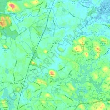
Name: Hamilton topographic map, elevation, terrain.
Location: Hamilton, Essex County, Massachusetts, United States (42.59341 -70.91991 42.66029 -70.80083)
Average elevation: 62 ft
Minimum elevation: -7 ft
Maximum elevation: 269 ft
Essex County trails, hiking, mountain biking, running and outdoor activities
Other topographic maps
Click on a map to view its topography, its elevation and its terrain.
Haverhill
United States > Massachusetts > Essex County > Haverhill
According to the United States Census Bureau, the city has a total area of 35.6 square miles (92.3 km2), of which 33.0 square miles (85.4 km2) is land and 2.7 square miles (6.9 km2), or 7.47%, is water. The city ranks 60th in the Commonwealth in terms of land area, and is the largest city or town in Essex…
Average elevation: 148 ft
Whaleback
United States > Massachusetts > Essex County > Manchester-by-the-Sea
Average elevation: 39 ft
Deer Island
United States > Massachusetts > Essex County > Amesbury > Salisbury Point
Average elevation: 49 ft
Magnolia
United States > Massachusetts > Essex County > Gloucester > Magnolia
Average elevation: 33 ft
Stevens Crossing
United States > Massachusetts > Essex County > North Andover
Average elevation: 167 ft
Dix Park
United States > Massachusetts > Essex County > Beverly > Beverly Farms
Average elevation: 62 ft
East Point/Henry Cabot Lodge,Jr., Memorial Park
United States > Massachusetts > Essex County > Nahant
Average elevation: 3 ft
Amesbury
United States > Massachusetts > Essex County > Amesbury
Amesbury is located at 42°51′29″N 70°55′50″W / 42.85806°N 70.93056°W / 42.85806; -70.93056. According to the United States Census Bureau, the city has a total area of 13.7 square miles (35.5 km2), of which 12.3 square miles (31.8 km2) is land and 1.5 square miles (3.8 km2), or 10.65%, is…
Average elevation: 79 ft
Veasey Memorial Park
United States > Massachusetts > Essex County > Groveland > South Groveland
Average elevation: 112 ft
South Salem
United States > Massachusetts > Essex County > Salem > South Salem
Average elevation: 36 ft