
Carney topographic map
Interactive map
Click on the map to display elevation.
About this map
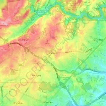
Name: Carney topographic map, elevation, terrain.
Location: Carney, Baltimore County, Maryland, 21234, United States (39.35427 -76.56358 39.43427 -76.48358)
Average elevation: 299 ft
Minimum elevation: 75 ft
Maximum elevation: 545 ft
Other topographic maps
Click on a map to view its topography, its elevation and its terrain.
Catonsville
United States > Maryland > Baltimore County
Catonsville, Baltimore County, Maryland, 21228, United States
Average elevation: 341 ft
Hereford
United States > Maryland > Baltimore County
Hereford, Baltimore County, Maryland, United States
Average elevation: 558 ft
Perry Hall
United States > Maryland > Baltimore County
Perry Hall, Baltimore County, Maryland, 21236, United States
Average elevation: 236 ft
Dundalk
United States > Maryland > Baltimore County
Dundalk, Baltimore County, Maryland, 21222, United States
Average elevation: 108 ft
Cockeysville
United States > Maryland > Baltimore County
Cockeysville, Baltimore County, Maryland, 21031, United States
Average elevation: 430 ft
Kingsville
United States > Maryland > Baltimore County
Kingsville, Baltimore County, Maryland, 21087, United States
Average elevation: 272 ft
Hydes
United States > Maryland > Baltimore County > Towson
Hydes, Towson, Baltimore County, Maryland, 21013, United States
Average elevation: 404 ft
Upperco
United States > Maryland > Baltimore County
Upperco, Baltimore County, Maryland, 21155, United States
Average elevation: 715 ft
Jacksonville
United States > Maryland > Baltimore County
Jacksonville, Baltimore County, Maryland, 21131, United States
Average elevation: 558 ft
Edgemere
United States > Maryland > Baltimore County
Edgemere, Baltimore County, Maryland, 21219, United States
Average elevation: 13 ft
Randallstown
United States > Maryland > Baltimore County
Randallstown, Baltimore County, Maryland, 21133, United States
Average elevation: 495 ft
Maryland Line
United States > Maryland > Baltimore County
Maryland Line, Baltimore County, Maryland, 21105, United States
Average elevation: 801 ft
Oregon
United States > Maryland > Baltimore County
Oregon, Baltimore County, Maryland, 21031, United States
Average elevation: 446 ft
Honeygo
United States > Maryland > Baltimore County
Honeygo, Baltimore County, Maryland, 21162, United States
Average elevation: 154 ft
Riderwood
United States > Maryland > Baltimore County
Riderwood, Baltimore County, Maryland, 21139, United States
Average elevation: 348 ft
Lutherville
United States > Maryland > Baltimore County
Lutherville, Baltimore County, Maryland, 21204, United States
Average elevation: 384 ft
Milford Mill
United States > Maryland > Baltimore County
Milford Mill, Baltimore County, Maryland, 21244, United States
Average elevation: 456 ft
Boring
United States > Maryland > Baltimore County
Boring, Baltimore County, Maryland, 21020, United States
Average elevation: 633 ft
Butler
United States > Maryland > Baltimore County
Butler, Baltimore County, Maryland, 21023, United States
Average elevation: 440 ft
Shepperd
United States > Maryland > Baltimore County
Shepperd, Baltimore County, Maryland, 21111, United States
Average elevation: 574 ft
Relay
United States > Maryland > Baltimore County
Relay, Baltimore County, Maryland, 21227, United States
Average elevation: 131 ft
White Hall
United States > Maryland > Baltimore County
White Hall, Baltimore County, Maryland, 21161, United States
Average elevation: 479 ft
Arbutus
United States > Maryland > Baltimore County
Arbutus, Baltimore County, Maryland, 21227, United States
Average elevation: 187 ft
Fork
United States > Maryland > Baltimore County > Kingsville
Fork, Kingsville, Baltimore County, Maryland, 21051, United States
Average elevation: 394 ft
Hart-Miller Island State Park
United States > Maryland > Baltimore County
Hart-Miller Island State Park, Baltimore County, Maryland, United States
Average elevation: 3 ft
Hampton
United States > Maryland > Baltimore County
Hampton, Baltimore County, Maryland, 21286, United States
Average elevation: 387 ft
Overlea
United States > Maryland > Baltimore County
Overlea, Baltimore County, Maryland, 21026, United States
Average elevation: 210 ft
Brooklandville
United States > Maryland > Baltimore County > Towson
Brooklandville, Towson, Baltimore County, Maryland, 21022, United States
Average elevation: 400 ft
Soldiers Delight Natural Environment Area
United States > Maryland > Baltimore County > Owings Mills
Soldiers Delight Natural Environment Area, Red Run Boulevard, Belltown, Owings Mills, Baltimore County, Maryland, 21117, United States
Average elevation: 614 ft
Rossville
United States > Maryland > Baltimore County > Rossville
Rossville, Baltimore County, Maryland, 21326, United States
Average elevation: 108 ft
Marshy Point
United States > Maryland > Baltimore County
Marshy Point, Baltimore County, Maryland, 21027, United States
Average elevation: 3 ft
Middle River
United States > Maryland > Baltimore County > Middle River
Middle River, Baltimore County, Maryland, 21220, United States
Average elevation: 43 ft
Lutherville
United States > Maryland > Baltimore County > Lutherville
Lutherville, Baltimore County, Maryland, United States
Average elevation: 381 ft
Cockeysville
United States > Maryland > Baltimore County > Cockeysville
Cockeysville, Baltimore County, Maryland, United States
Average elevation: 394 ft
Reisterstown
United States > Maryland > Baltimore County
Reisterstown, Baltimore County, Maryland, 21136, United States
Average elevation: 600 ft
Parkville
United States > Maryland > Baltimore County > Parkville
Parkville, Baltimore County, Maryland, 21234, United States
Average elevation: 364 ft
Parkton
United States > Maryland > Baltimore County
Parkton, Baltimore County, Maryland, 21120, United States
Average elevation: 545 ft
Pikesville
United States > Maryland > Baltimore County > Pikesville
Pikesville, Baltimore County, Maryland, United States
Average elevation: 443 ft
Carney
United States > Maryland > Baltimore County > Oakleigh
Carney, Oakleigh, Baltimore County, Maryland, United States
Average elevation: 338 ft
Essex
United States > Maryland > Baltimore County
Essex, Baltimore County, Maryland, 21221, United States
Average elevation: 46 ft
Baldwin
United States > Maryland > Baltimore County
Baldwin, Baltimore County, Maryland, 21082, United States
Average elevation: 427 ft
Dundalk
United States > Maryland > Baltimore County > North Point Village
Dundalk, North Point Village, Baltimore County, Maryland, 21222, United States
Average elevation: 20 ft
Yeoho
United States > Maryland > Baltimore County
Yeoho, Baltimore County, Maryland, 21023, United States
Average elevation: 591 ft
Kingsville
United States > Maryland > Baltimore County > Kingsville
Kingsville, Baltimore County, Maryland, 21087, United States
Average elevation: 279 ft
Arbutus
United States > Maryland > Baltimore County > Relay
Arbutus, Relay, Baltimore County, Maryland, United States
Average elevation: 138 ft
Hoffmanville
United States > Maryland > Baltimore County > Hoffmanville
Hoffmanville, Baltimore County, Maryland, 21088, United States
Average elevation: 732 ft
Timonium
United States > Maryland > Baltimore County > Timonium
Timonium, Baltimore County, Maryland, United States
Average elevation: 371 ft
White Marsh
United States > Maryland > Baltimore County > White Marsh
White Marsh, Baltimore County, Maryland, United States
Average elevation: 128 ft
Pikesville
United States > Maryland > Baltimore County
Pikesville, Baltimore County, Maryland, 21208, United States
Average elevation: 463 ft
Bowleys Quarters
United States > Maryland > Baltimore County > Bowleys Quarters
Bowleys Quarters, Baltimore County, Maryland, United States
Average elevation: 7 ft