
Make a donation
Gear up for your next adventure:
As an Amazon Associate, this site earns from qualifying purchases at no extra cost to you.
Luangwa topographic map
Click on the map to display elevation.
Make a donation
Gear up for your next adventure:
As an Amazon Associate, this site earns from qualifying purchases at no extra cost to you.
Luangwa
Note: distances stated are approximate straight-line distances from source. The Luangwa rises in the Lilonda and Mafinga Hills in north-east Zambia at an elevation of around 1500 m, near the border with Tanzania and Malawi, and flows in a southwesterly direction through a broad valley. About 150 km from its source it has dropped to an elevation of about 690 m and becomes a meandering river with a flood-plain several kilometres wide. Over the next 300 km the meanders increase, with many oxbow lakes and abandoned meanders. Near Mfuwe, the river's elevation has dropped to about 520 m, the flood plain is about 10 km wide and the valley reaches about 100 km wide, with a north-west escarpment (Muchinga Escarpment) about 700 m high, and a south-western escarpment about 450 m high. In the dry season some sections, especially in the upper reaches, dry out completely, leaving isolated pools.
Make a donation
Gear up for your next adventure:
As an Amazon Associate, this site earns from qualifying purchases at no extra cost to you.
About this map
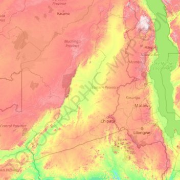
Name: Luangwa topographic map, elevation, terrain.
Location: Luangwa, Zambia (-15.62092 30.19639 -9.85132 33.32065)
Average elevation: 3,268 ft
Minimum elevation: 945 ft
Maximum elevation: 8,274 ft
Make a donation
Gear up for your next adventure:
As an Amazon Associate, this site earns from qualifying purchases at no extra cost to you.
Other topographic maps
Click on a map to view its topography, its elevation and its terrain.
Mufulira
The geographical coordinates of Mufulira are:12°32'08.0"S, 28°14'31.0"E (Latitude:-12.535556; Longitude:28.241944). Mufulira sits at an average elevation of 4,180 feet (1,274 m) above mean sea level.
Average elevation: 4,183 ft
Make a donation
Gear up for your next adventure:
As an Amazon Associate, this site earns from qualifying purchases at no extra cost to you.
Make a donation
Gear up for your next adventure:
As an Amazon Associate, this site earns from qualifying purchases at no extra cost to you.
Make a donation
Gear up for your next adventure:
As an Amazon Associate, this site earns from qualifying purchases at no extra cost to you.
Make a donation
Gear up for your next adventure:
As an Amazon Associate, this site earns from qualifying purchases at no extra cost to you.