Make a donation
Gear up for your next adventure:
As an Amazon Associate, this site earns from qualifying purchases at no extra cost to you.
Straubing topographic map
Click on the map to display elevation.
Make a donation
Gear up for your next adventure:
As an Amazon Associate, this site earns from qualifying purchases at no extra cost to you.
About this map
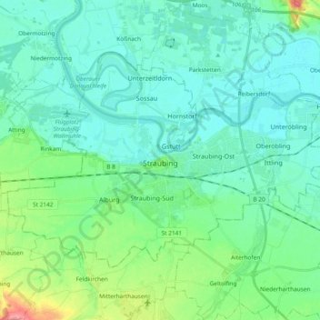
Name: Straubing topographic map, elevation, terrain.
Location: Straubing, Bavaria, 94315, Germany (48.84171 12.48022 48.92463 12.66709)
Average elevation: 1,083 ft
Minimum elevation: 1,024 ft
Maximum elevation: 1,316 ft
Make a donation
Gear up for your next adventure:
As an Amazon Associate, this site earns from qualifying purchases at no extra cost to you.
Other topographic maps
Click on a map to view its topography, its elevation and its terrain.
Make a donation
Gear up for your next adventure:
As an Amazon Associate, this site earns from qualifying purchases at no extra cost to you.
Make a donation
Gear up for your next adventure:
As an Amazon Associate, this site earns from qualifying purchases at no extra cost to you.
Make a donation
Gear up for your next adventure:
As an Amazon Associate, this site earns from qualifying purchases at no extra cost to you.
Soiernsee
Germany > Bavaria > Landkreis Garmisch-Partenkirchen > Mittenwald
Average elevation: 5,794 ft
Untersalzberg I
Germany > Bavaria > Landkreis Berchtesgadener Land > Berchtesgaden
Average elevation: 2,487 ft
Make a donation
Gear up for your next adventure:
As an Amazon Associate, this site earns from qualifying purchases at no extra cost to you.
Hintersee
Germany > Bavaria > Landkreis Berchtesgadener Land > Ramsau bei Berchtesgaden
Average elevation: 3,297 ft
Make a donation
Gear up for your next adventure:
As an Amazon Associate, this site earns from qualifying purchases at no extra cost to you.
Fribertshofen
Germany > Bavaria > Landkreis Neumarkt in der Oberpfalz > Berching
Average elevation: 1,637 ft
Make a donation
Gear up for your next adventure:
As an Amazon Associate, this site earns from qualifying purchases at no extra cost to you.
Make a donation
Gear up for your next adventure:
As an Amazon Associate, this site earns from qualifying purchases at no extra cost to you.
Bürstenstiel
Germany > Bavaria > Landkreis Weilheim-Schongau > Bernbeuren > Bürstenstiel
Average elevation: 2,631 ft
Make a donation
Gear up for your next adventure:
As an Amazon Associate, this site earns from qualifying purchases at no extra cost to you.
Tittmoning
Germany > Bavaria > Landkreis Traunstein > Tittmoning > Tittmoning
Average elevation: 1,421 ft
Deisenhofen
Germany > Bavaria > Landkreis München > Oberhaching > Deisenhofen
Average elevation: 1,942 ft
Feldkirchen
Germany > Bavaria > Landkreis München > Feldkirchen > Feldkirchen
Average elevation: 1,719 ft
Make a donation
Gear up for your next adventure:
As an Amazon Associate, this site earns from qualifying purchases at no extra cost to you.
Bad Kissingen
Germany > Bavaria > Landkreis Bad Kissingen > Bad Kissingen > Bad Kissingen
Average elevation: 968 ft
Kevenhüll
Germany > Bavaria > Landkreis Eichstätt > Beilngries > Kevenhüll
Average elevation: 1,585 ft
Birkenfeld
Germany > Bavaria > Landkreis Neustadt an der Aisch-Bad Windsheim > Neustadt an der Aisch > Birkenfeld
Average elevation: 1,050 ft
Make a donation
Gear up for your next adventure:
As an Amazon Associate, this site earns from qualifying purchases at no extra cost to you.
Egloffstein
Germany > Bavaria > Landkreis Forchheim > Egloffstein > Egloffstein
Average elevation: 1,512 ft
Make a donation
Gear up for your next adventure:
As an Amazon Associate, this site earns from qualifying purchases at no extra cost to you.
Make a donation
Gear up for your next adventure:
As an Amazon Associate, this site earns from qualifying purchases at no extra cost to you.
Oberschwaben
Due to Upper Swabia's altitude and hilly terrain, agriculture consists mainly of dairy farming, the exception being the basin of the river Schussen, where the predominant produce is hops and fruits.
Average elevation: 2,723 ft
Make a donation
Gear up for your next adventure:
As an Amazon Associate, this site earns from qualifying purchases at no extra cost to you.
Altbachhaus
Germany > Bavaria > Landkreis Freyung-Grafenau > Grafenau > Schlag
Average elevation: 2,044 ft
Make a donation
Gear up for your next adventure:
As an Amazon Associate, this site earns from qualifying purchases at no extra cost to you.
