Geolocate

Meadowlakes topographic map

Click on the map to display elevation.

About this map

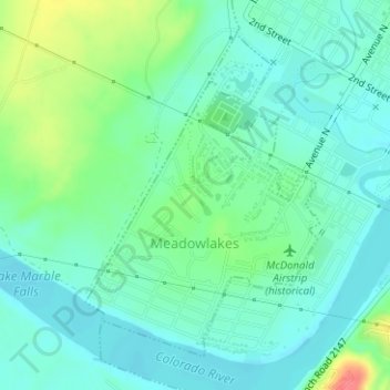
Name: Meadowlakes topographic map, elevation, terrain.

Location: Meadowlakes, Burnet County, Texas, United States (30.55453 -98.30521 30.57687 -98.28635)

Average elevation: 791 ft

Minimum elevation: 735 ft

Maximum elevation: 938 ft

Burnet County trails, hiking, mountain biking, running and outdoor activities

Other topographic maps

Click on a map to view its topography, its elevation and its terrain.

Joppa

United States > Texas > Burnet County

Average elevation: 1,122 ft

Naruna

United States > Texas > Burnet County

Average elevation: 1,460 ft

Spider Mountain

United States > Texas > Burnet County

Average elevation: 1,122 ft

Bertram

United States > Texas > Burnet County > Bertram > Bertram

Average elevation: 1,220 ft

Rocky Point

United States > Texas > Burnet County

Average elevation: 1,056 ft

Gear up for your next adventure:

🎒Hydration Pack - Hands‑free water reservoir for long hikes
🥾Men's Hiking Boots - Durable, waterproof footwear for rugged terrain and steep inclines
🌲Outdoor Survival Books - Best books on survival skills
Backpacking Tent - Lightweight and durable tent for multi‑day hikes
🧤Hiking Gloves - Protective gloves for rugged trails

As an Amazon Associate, this site earns from qualifying purchases at no extra cost to you.