Geolocate

Chockie topographic map

Click on the map to display elevation.

About this map

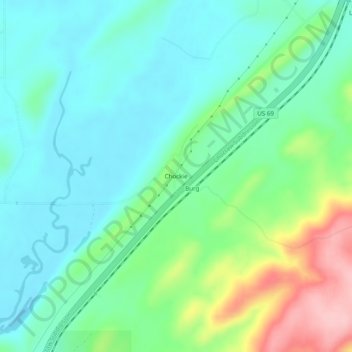
Name: Chockie topographic map, elevation, terrain.

Location: Chockie, Atoka County, Oklahoma, United States (34.56204 -96.01833 34.60204 -95.97833)

Average elevation: 725 ft

Minimum elevation: 581 ft

Maximum elevation: 1,119 ft

Atoka County trails, hiking, mountain biking, running and outdoor activities

Other topographic maps

Click on a map to view its topography, its elevation and its terrain.

Atoka

United States > Oklahoma > Atoka County

Average elevation: 604 ft

Caney

United States > Oklahoma > Atoka County

Average elevation: 554 ft

Tushka

United States > Oklahoma > Atoka County

Average elevation: 617 ft

Stringtown

United States > Oklahoma > Atoka County

Average elevation: 646 ft

Gear up for your next adventure:

🗺️NatGeo Topo Maps - High-quality waterproof printed topographic maps of US Parks
🧤Hiking Gloves - Protective gloves for rugged trails
💧Water Purification System - Clean water on the trail with reliable purifiers
👟Trail Running Shoes - Lightweight shoes for trail runners
🔋Solar Power Banks - Keep your GPS and phone charged in remote wilderness areas

As an Amazon Associate, this site earns from qualifying purchases at no extra cost to you.