Geolocate

Madhubani topographic map

Click on the map to display elevation.

About this map

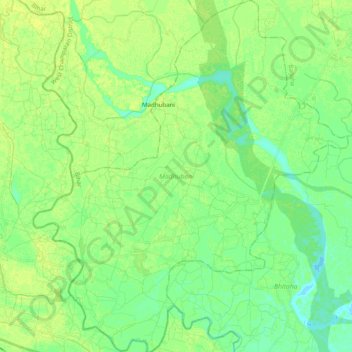
Name: Madhubani topographic map, elevation, terrain.

Location: Madhubani, West Champaran District, Bihar, 845104, India (26.87614 84.03242 27.05160 84.20864)

Average elevation: 279 ft

Minimum elevation: 253 ft

Maximum elevation: 299 ft

Other topographic maps

Click on a map to view its topography, its elevation and its terrain.

Gaya

India > Bihar > Gaya Town C.D.Block

Gaya is connected to the rest of India by roads, rail and airways. The Grand Chord section of the Indian Railways passes through Gaya. Gaya Junction railway station railway station is a major junction station serving the city. Gaya Junction has been redeveloped as Model railway station recently and houses all…

Average elevation: 364 ft

Marhaura

India > Bihar > Marhaura

Average elevation: 184 ft

Sonbhadra

India > Bihar > Sonbhadra Banshi Suryapur

Average elevation: 243 ft

Saran

India > Bihar > Chakai

Average elevation: 1,102 ft

Begusarai

India > Bihar > Begusarai

Begusarai is located at 25°25′N 86°08′E / 25.42°N 86.13°E / 25.42; 86.13. It has an average elevation of 41 metres (134 feet). Begusarai lies in North Bihar and is surrounded by Khagaria in the northeast, Munger in the southeast, Patna in the west, and Samastipur in the northwest.

Average elevation: 135 ft

Bhojpur

India > Bihar

Average elevation: 341 ft

Purnia

India > Bihar

Average elevation: 177 ft

Saharsa

India > Bihar

Average elevation: 177 ft

Sitamarhi

India > Bihar > Dumra

Sitamarhi, located at 26°36′N 85°29′E / 26.6°N 85.48°E / 26.6; 85.48, has an average elevation of 56 metres (184 ft).

Average elevation: 210 ft

Darbhanga

India > Bihar > Darbhanga

Darbhanga is located in the northern part of Bihar. It lies between 25.53 degrees - 26.27 degrees N and 85.45 degrees - 86.25 degrees E at an average elevation of 171 feet (52 m). Darbhanga district covers an area of 2,279 sq km. Darbhanga is bounded by Madhubani district on north, by Samastipur district on…

Average elevation: 164 ft

Neamatpur

India > Bihar > Barsoi

Average elevation: 112 ft

Purnia

India > Bihar > Purnia East > Purnia

Average elevation: 125 ft

Nalanda

India > Bihar > Silao > Kapatia

Average elevation: 194 ft

Falgu

India > Bihar > Ghoswari > Ghoswari

Average elevation: 135 ft

Pashchim Champāran

India > Bihar

Average elevation: 679 ft

Gehlour Ghati

India > Bihar > Muhra

Average elevation: 364 ft

Silao

India > Bihar > Silao

Average elevation: 203 ft

Gear up for your next adventure:

🪓Survival Multi‑Tool - Versatile tool for camp and trail tasks
🎁Geography Themed Gifts - Unique gift ideas for map lovers and geography enthusiasts
🌡️Handheld Weather Meters - Measure wind, temp, and pressure for safe mountain travel
🎒Day Hiking Backpack - Lightweight backpack perfect for day trips and outdoor adventures
🚗GPS Dash Cams - Record your scenic drives through mountain passes and canyons

As an Amazon Associate, this site earns from qualifying purchases at no extra cost to you.