
Make a donation
Gear up for your next adventure:
As an Amazon Associate, this site earns from qualifying purchases at no extra cost to you.
Pando topographic map
Click on the map to display elevation.
Make a donation
Gear up for your next adventure:
As an Amazon Associate, this site earns from qualifying purchases at no extra cost to you.
Pando
At an altitude of 280 metres above sea level in the northwestern jungle region, Pando is located in the rainiest part of Bolivia. Pando has a hot climate, with temperatures commonly above 26 degrees Celsius (80 Fahrenheit).
Make a donation
Gear up for your next adventure:
As an Amazon Associate, this site earns from qualifying purchases at no extra cost to you.
About this map
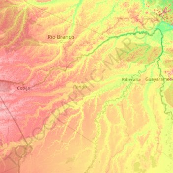
Name: Pando topographic map, elevation, terrain.
Location: Pando, Bolivia (-12.49797 -69.57181 -9.66894 -65.28471)
Average elevation: 568 ft
Minimum elevation: 289 ft
Maximum elevation: 1,237 ft
Make a donation
Gear up for your next adventure:
As an Amazon Associate, this site earns from qualifying purchases at no extra cost to you.
Other topographic maps
Click on a map to view its topography, its elevation and its terrain.
Copacabana
Bolivia > La Paz > Provincia Manco Kapac
Copacabana has a cold subtropical highland climate (Cwc), a rare variant of this type of climate, but commonplace near most of Lake Titicaca. Similar to many areas with this climate, Copacabana features a markedly drier "low-sun" season. Because of the high altitude of Copacabana, the town is chilly throughout…
Average elevation: 12,677 ft
Pampa Grande
Bolivia > Tarija > Eustaquio Méndez > Municipio Villa San Lorenzo
Average elevation: 5,007 ft
Make a donation
Gear up for your next adventure:
As an Amazon Associate, this site earns from qualifying purchases at no extra cost to you.
Yacuiba
Bolivia > Tarija > Gran Chaco
Yacuiba has a dry-winter humid subtropical climate (Köppen: Cwa), a result of its slightly cooler temperatures when compared to surrounding regions because of its modest elevation and the monsoonal effects of the surrounding area.
Average elevation: 2,306 ft
Make a donation
Gear up for your next adventure:
As an Amazon Associate, this site earns from qualifying purchases at no extra cost to you.
Puerto Villarroel
Bolivia > Cochabamba > Carrasco > Municipio Puerto Villarroel
Average elevation: 620 ft
Del Norte
Bolivia > Santa Cruz > Provincia Ñuflo de Chávez > Municipio Cuatro Cañadas
Average elevation: 827 ft
Make a donation
Gear up for your next adventure:
As an Amazon Associate, this site earns from qualifying purchases at no extra cost to you.
Make a donation
Gear up for your next adventure:
As an Amazon Associate, this site earns from qualifying purchases at no extra cost to you.
Tacuarembo
Bolivia > Santa Cruz > Provincia Cordillera > Municipio Charagua
Average elevation: 2,956 ft
Achacachi
Bolivia > La Paz > Provincia Omasuyos > Municipio Achacachi
Achacachi is at an elevation of 3,854 m or 12.647 feet amsl on the Achacachi peninsula on the eastern shores of Lake Titicaca, 96 km (60 mi) northwest of the capital La Paz.
Average elevation: 12,595 ft
Make a donation
Gear up for your next adventure:
As an Amazon Associate, this site earns from qualifying purchases at no extra cost to you.
#08-BO, Quebrada Colorada, afluente do Rio Achira, Estación Biológica Cuevas, Ruta 7
Bolivia > Santa Cruz > Provincia Florida > Municipio Samaipata > Cuevas
Average elevation: 4,573 ft
San Antonio
Bolivia > Tarija > Provincia Méndez > Municipio Tomayapo (El Puente)
Average elevation: 11,325 ft
Make a donation
Gear up for your next adventure:
As an Amazon Associate, this site earns from qualifying purchases at no extra cost to you.
Totora
Bolivia > Cochabamba > Municipio Totora
Totora is noted for having colonial-style building and architecture. Because of the town's topography, the streets have an atypical distribution. The most common style of house includes adobe walls, land floors, and cement roofing. From 1999 to 2005, 44.2% of the households use firewood to power their house,…
Average elevation: 9,416 ft
Villa Gonzales
Bolivia > Beni > General José Ballivián Segurola > San Borja > Villa Gonzales
Average elevation: 614 ft
Make a donation
Gear up for your next adventure:
As an Amazon Associate, this site earns from qualifying purchases at no extra cost to you.
Monte Punku
Bolivia > Cochabamba > Carrasco > Municipio Totora > Cocapata > Monte Punku
Average elevation: 9,531 ft
Río Rocha
Bolivia > Cochabamba > Capinota > Municipio Capinota > Buen Retiro
Average elevation: 8,114 ft
Cochabamba
Bolivia > Pando > Provincia de Manuripi > Municipio Puerto Rico > Cochabamba
Average elevation: 574 ft
San Marcos
Bolivia > Potosí > Provincia Modesto Omiste > Villazón > San Marcos
Average elevation: 10,030 ft
Make a donation
Gear up for your next adventure:
As an Amazon Associate, this site earns from qualifying purchases at no extra cost to you.
Villa Santa Ana
Bolivia > Potosí > Provincia General Bernardino Bilbao Rioja > Municipio Acasio > Villa Santa Ana
Average elevation: 10,030 ft
Montevideo Puerto Evo
Bolivia > Pando > Nicolás Suárez > Municipio Bella Flor > Montevideo Puerto Evo
Average elevation: 427 ft
Make a donation
Gear up for your next adventure:
As an Amazon Associate, this site earns from qualifying purchases at no extra cost to you.
Make a donation
Gear up for your next adventure:
As an Amazon Associate, this site earns from qualifying purchases at no extra cost to you.
Santiago de Chiquitos
Bolivia > Santa Cruz > Chiquitos > Roboré > Santiago de Chiquitos
Average elevation: 2,113 ft
Machareti
Bolivia > Chuquisaca > Provincia Luis Calvo > Municipio Machareti > Machareti
Average elevation: 2,169 ft
Make a donation
Gear up for your next adventure:
As an Amazon Associate, this site earns from qualifying purchases at no extra cost to you.
Provincia Manuel María Caballero
Bolivia > Santa Cruz > Provincia Manuel M. Caballero > Municipio Comarapa
Average elevation: 7,566 ft
Ankara
Bolivia > La Paz > Provincia General José Manuel Pando > Municipio Catacora
Average elevation: 14,035 ft
Make a donation
Gear up for your next adventure:
As an Amazon Associate, this site earns from qualifying purchases at no extra cost to you.
San Andres de Machaca
Bolivia > La Paz > Ingavi > Municipio San Andrés de Machaca
Average elevation: 12,864 ft
Make a donation
Gear up for your next adventure:
As an Amazon Associate, this site earns from qualifying purchases at no extra cost to you.
Laguna Colorada
Bolivia > Potosí > Provincia Sur Lípez > Municipio San Pablo de Lipez
Average elevation: 14,114 ft
Arica
Bolivia > Pando > Provincia del General Federico Román > Municipio Santos Mercado
Average elevation: 361 ft
Make a donation
Gear up for your next adventure:
As an Amazon Associate, this site earns from qualifying purchases at no extra cost to you.