
Altusried topographic map
Click on the map to display elevation.
Altusried
Die Höhenlage der Gemeinde reicht von 622 m ü. NHN an der Iller bei Fluhmühle (zugleich niedrigster Punkt des Landkreises Oberallgäu) bis 962 m ü. NHN im Hohentanner Wald.
About this map
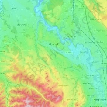
Name: Altusried topographic map, elevation, terrain.
Location: Altusried, Landkreis Oberallgäu, Bayern, 87452, Deutschland (47.74341 10.06505 47.84053 10.29066)
Average elevation: 2,503 ft
Minimum elevation: 2,024 ft
Maximum elevation: 3,648 ft
Other topographic maps
Click on a map to view its topography, its elevation and its terrain.
Immenstadt im Allgäu
Deutschland > Bayern > Landkreis Oberallgäu > Immenstadt im Allgäu
Average elevation: 2,986 ft
Grünten
Deutschland > Bayern > Landkreis Oberallgäu > Rettenberg > Wagneritz
Der Grünten gehört in der naturräumlichen Haupteinheitengruppe Nördliche Kalk-Westalpen (Nr. 95) und in der Haupteinheit Vorarlberg-Allgäuer Quintner- und Schrattenkalkgewölbe (950) zum Naturraum Grünten (950.0). Nach Norden leitet die Landschaft in die Untereinheit Rettenberger Tal (024.1) über und…
Average elevation: 3,678 ft
Oberschwarzenberg
Deutschland > Bayern > Landkreis Oberallgäu > Oy-Mittelberg > Unterschwarzenberg
Average elevation: 2,920 ft
Freibergsee
Deutschland > Bayern > Landkreis Oberallgäu
Der Freibergsee liegt im Süden von Oberstdorf, der südlichsten Gemeinde Deutschlands, im Landkreis Oberallgäu in Bayern in 930 m Höhe auf dem bewaldeten Freiberg.
Average elevation: 3,268 ft
Großer Alpsee
Deutschland > Bayern > Landkreis Oberallgäu > Immenstadt im Allgäu > Bühl am Alpsee
Weniger als 200 Meter oberhalb des westlichen Ufers liegt der 4,6 ha große Teufelssee, ein Restgewässer aus der Zeit, als der See noch weiter nach Westen reichte. Er liegt im Naturpark Nagelfluhkette und grenzt im Norden an den Salmaser Höhenzug, der die nördliche Grenze der Allgäuer Alpen darstellt. Im…
Average elevation: 2,694 ft
Gunzesried
Deutschland > Bayern > Landkreis Oberallgäu
Gunzesried ist ein Dorf und Ortsteil der bayerischen Gemeinde Blaichach im Allgäu. Er liegt in knapp 900 m Höhe in einem Hochtal.
Average elevation: 3,255 ft
Unterjoch
Deutschland > Bayern > Landkreis Oberallgäu > Bad Hindelang
Unterjoch ist ein Ortsteil des Marktes Bad Hindelang mit ungefähr 420 Einwohnern, der auf einer Höhe von 1013 m über NN liegt. Er ist heute touristisch geprägt.
Average elevation: 3,894 ft
Thaler Höhe
Deutschland > Bayern > Landkreis Oberallgäu > Missen-Wilhams
Die Thaler Höhe ist ein 1167 m ü. NHN hoher Nebengipfel der Salmaser Höhe in den Allgäuer Alpen oder wahlweise im Bayerischen Alpenvorland, da die beiden Naturräume nicht einheitlich voneinander abgegrenzt werden. Sie liegt im Landkreis Oberallgäu in der Gemarkung der Gemeinde Missen-Wilhams.
Average elevation: 3,248 ft
Emmereis
Deutschland > Bayern > Landkreis Oberallgäu > Rettenberg > Vorderburg
Average elevation: 2,936 ft
Nebelhorn
Deutschland > Bayern > Landkreis Oberallgäu > Oberstdorf
Die Schartenhöhe des Nebelhorns beträgt mindestens 24 Meter, seine Dominanz 500 Meter, wobei jeweils der Westliche Wengenkopf Referenzberg ist.
Average elevation: 5,879 ft
Tiefenbach
Deutschland > Bayern > Landkreis Oberallgäu > Oberstdorf > Tiefenbach
Average elevation: 3,186 ft
Steibis
Deutschland > Bayern > Landkreis Oberallgäu
Steibis ist ein Ortsteil in der Gemarkung Aach im Allgäu des Marktes Oberstaufen im bayerisch-schwäbischen Landkreis Oberallgäu. Es liegt auf einer leicht abfallenden Hochebene zwischen dem nördlichen Weissachtal und der südlich liegenden Hochgratkette auf einer Höhe von 860 m. Hausberge sind der…
Average elevation: 2,867 ft
Sulzberger See
Deutschland > Bayern > Landkreis Oberallgäu > Sulzberg > Thal
Average elevation: 2,352 ft
Hintersteiner Tal
Deutschland > Bayern > Landkreis Oberallgäu > Bad Hindelang
Average elevation: 4,593 ft
Vorderhindelang
Deutschland > Bayern > Landkreis Oberallgäu > Bad Hindelang
Average elevation: 3,392 ft
Oberstdorf
Deutschland > Bayern > Landkreis Oberallgäu > Oberstdorf > Oberstdorf
Average elevation: 3,602 ft
Gschnaidt
Deutschland > Bayern > Landkreis Oberallgäu > Altusried > Gschnaidt
Average elevation: 2,677 ft
Burgberg
Deutschland > Bayern > Landkreis Oberallgäu > Burgberg im Allgäu
Die Wahlbeteiligung lag bei 72,29 % und damit um 8,2 % höher als 2014. Gegenüber 2014 verloren CSU und Freie Wähler jeweils einen Sitz, die Unabhängige Liste konnte ein Mandat dazu gewinnen. Während die SPD (bisher zwei Sitze) keinen Wahlvorschlag mehr einreichte, bewarben sich Die Grünen neu und…
Average elevation: 2,795 ft
Knottenried
Deutschland > Bayern > Landkreis Oberallgäu > Immenstadt im Allgäu
Der Höhenfestpunkt für Knottenried ist in die Mauer der Pfarrkirche eingeschlagen und liegt auf 1003 m über NHN. Der mit 1056 m ü. NHN höchste Punkt der Pfarrei ist westlich von Knottenried auf der im amtlichen Grundbeschrieb als „Prageck“ benannten Flurbezeichnung. Der tiefste Punkt ist das…
Average elevation: 3,110 ft
Obergschwend
Deutschland > Bayern > Landkreis Oberallgäu > Bad Hindelang > Unterjoch
Average elevation: 4,055 ft
Ofterschwanger Horn
Deutschland > Bayern > Landkreis Oberallgäu > Ofterschwang
Average elevation: 3,796 ft
Buchenegger Wasserfälle
Deutschland > Bayern > Landkreis Oberallgäu > Oberstaufen
Average elevation: 3,028 ft
Schochen
Deutschland > Bayern > Landkreis Oberallgäu > Oberstdorf
Die Schartenhöhe des Schochens beträgt mindestens 60 Meter, seine Dominanz 800 Meter, wobei jeweils der Lachenkopf Referenzberg ist.
Average elevation: 5,390 ft