
Velletri topographic map
Click on the map to display elevation.
Velletri
The old town's altitude is substantially uniform from the elevation of Piazza Giuseppe Garibaldi at 339 m above sea level, the square of the Trivium at 332 metres (1,089 feet) above sea level, and Napoletana at 329 metres (1,079 feet) above sea level. The area west of the walled city is a bit higher at San Lorenzo reaching 372 m (1,220 ft) above sea level. The remainder of the territory to the south and west is basically flat except for small hills that do not exceed 300 m (984 ft) above sea level.
About this map
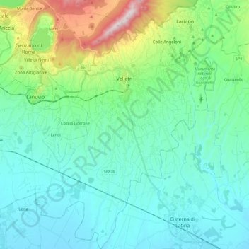
Name: Velletri topographic map, elevation, terrain.
Location: Velletri, Roma Capitale, Lazio, 00049, Italy (41.57274 12.69749 41.73926 12.84085)
Average elevation: 741 ft
Minimum elevation: 167 ft
Maximum elevation: 3,058 ft
Other topographic maps
Click on a map to view its topography, its elevation and its terrain.
Rome
Italy > Lazio > Roma Capitale
Although the city centre is about 24 km (15 mi) inland from the Tyrrhenian Sea, the city territory extends to the shore, where the south-western district of Ostia is located. The altitude of the central part of Rome ranges from 13 m (43 ft) above sea level (at the base of the Pantheon) to 139 m (456 ft) above…
Average elevation: 256 ft
Villa d'Este
Italy > Lazio > Roma Capitale > Tivoli
Tivoli had been a popular summer residence since ancient Roman times due to its altitude, cooler temperatures and its proximity to the Villa Hadriana, the summer residence of the Emperor Hadrian I. The position of Governor of Tivoli came with an official residence located in a former convent of the Benedictine…
Average elevation: 666 ft
Palatine Hill
Italy > Lazio > Roma Capitale > Rome
In 2007 the legendary Lupercal cave was claimed to have been found beneath the remains of the Domus Livia (House of Livia) on the Palatine. Archaeologists came across the 16-metre-deep cavity while restoring the decaying palace, with a richly decorated vault encrusted with mosaics and seashells. The Lupercal…
Average elevation: 131 ft
Colle Tocciarello
Italy > Lazio > Roma Capitale > Valmontone > Villaggio Rinascita
Average elevation: 912 ft
Area di sosta turistica Info Point Appia Antica X-XI miglio
Italy > Lazio > Roma Capitale > Marino > Poggio delle Mole
Average elevation: 499 ft
Monte Gennaro
Italy > Lazio > Roma Capitale > San Polo dei Cavalieri
Monte Gennaro is a peak in the Monti Lucretili, in Lazio, central Italy. It has an elevation of 1,271 metres (4,170 ft) and is the highest peak visible from Rome looking eastwards. It is located in the province of Rome, in the communal territories of Palombara Sabina and San Polo dei Cavalieri.
Average elevation: 3,051 ft