
双桥区 topographic map
Interactive map
Click on the map to display elevation.
About this map
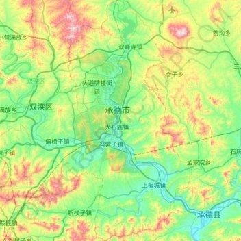
Name: 双桥区 topographic map, elevation, terrain.
Location: 双桥区, 承德市, 河北省, 067000, 中国 (40.72567 117.83978 41.13670 118.12550)
Average elevation: 1,732 ft
Minimum elevation: 833 ft
Maximum elevation: 4,121 ft
Other topographic maps
Click on a map to view its topography, its elevation and its terrain.