
El Badrashein topographic map
Interactive map
Click on the map to display elevation.
About this map
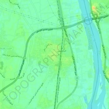
Name: El Badrashein topographic map, elevation, terrain.
Location: El Badrashein, Giza, 12918, Egypt (29.83133 31.25441 29.87133 31.29441)
Average elevation: 72 ft
Minimum elevation: 39 ft
Maximum elevation: 125 ft
Other topographic maps
Click on a map to view its topography, its elevation and its terrain.
Sheikh Zayed City
Egypt > Giza > Sheikh Zayed City
Sheikh Zayed City, Giza, 12593, Egypt
Average elevation: 338 ft
El Hassana Dome Protectorate
Egypt > Giza > Sheikh Zayed
El Hassana Dome Protectorate, Sheikh Zayed, Giza, Egypt
Average elevation: 354 ft
Al Hosary park
Egypt > Giza > Sixth of October
Al Hosary park, Neighborhood 1, 8th District, Sixth of October, Giza, Egypt
Average elevation: 604 ft
Nazlet Al Siman and Al Sisi
Egypt > Giza > Remaya Square
Nazlet Al Siman and Al Sisi, Remaya Square, Giza, Egypt
Average elevation: 138 ft