
Make a donation
Gear up for your next adventure:
As an Amazon Associate, this site earns from qualifying purchases at no extra cost to you.
Springfield Township topographic map
Click on the map to display elevation.
Make a donation
Gear up for your next adventure:
As an Amazon Associate, this site earns from qualifying purchases at no extra cost to you.
About this map
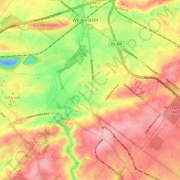
Name: Springfield Township topographic map, elevation, terrain.
Average elevation: 269 ft
Minimum elevation: -115 ft
Maximum elevation: 453 ft
Montgomery County trails, hiking, mountain biking, running and outdoor activities
Make a donation
Gear up for your next adventure:
As an Amazon Associate, this site earns from qualifying purchases at no extra cost to you.
Other topographic maps
Click on a map to view its topography, its elevation and its terrain.
Huntingdon Valley
United States > Pennsylvania > Montgomery County > Lower Moreland Township
Average elevation: 213 ft
Three Tuns
United States > Pennsylvania > Montgomery County > Upper Dublin Township > Maple Glen
Average elevation: 331 ft
Hidden Valley
United States > Pennsylvania > Montgomery County > Upper Merion Township
Average elevation: 154 ft
Marble Hall
United States > Pennsylvania > Montgomery County > Whitemarsh Township
Average elevation: 210 ft
Make a donation
Gear up for your next adventure:
As an Amazon Associate, this site earns from qualifying purchases at no extra cost to you.
Fagleysville
United States > Pennsylvania > Montgomery County > New Hanover Township
Average elevation: 344 ft
Woxall
United States > Pennsylvania > Montgomery County > Upper Salford Township
Average elevation: 322 ft
Fitzwatertown
United States > Pennsylvania > Montgomery County > Upper Dublin Township
Average elevation: 282 ft
Lafayette Hill
United States > Pennsylvania > Montgomery County > Whitemarsh Township
Average elevation: 194 ft
Make a donation
Gear up for your next adventure:
As an Amazon Associate, this site earns from qualifying purchases at no extra cost to you.
Limerick
United States > Pennsylvania > Montgomery County > Limerick Township
Average elevation: 282 ft
Plymouth Meeting
United States > Pennsylvania > Montgomery County > Whitemarsh Township
Average elevation: 177 ft
Enfield
United States > Pennsylvania > Montgomery County > Springfield Township > Wyndmoor
Average elevation: 285 ft
Ashmead Village
United States > Pennsylvania > Montgomery County > Cheltenham Township > Cheltenham
Average elevation: 167 ft
Make a donation
Gear up for your next adventure:
As an Amazon Associate, this site earns from qualifying purchases at no extra cost to you.
Gladwyne
United States > Pennsylvania > Montgomery County > Lower Merion Township
Average elevation: 302 ft
Mont Clare
United States > Pennsylvania > Montgomery County > Upper Providence Township
Average elevation: 184 ft
Evansburg State Park
United States > Pennsylvania > Montgomery County > Worcester Township > Cedars
Average elevation: 230 ft
Bala Cynwyd
United States > Pennsylvania > Montgomery County > Lower Merion Township
Average elevation: 249 ft
Make a donation
Gear up for your next adventure:
As an Amazon Associate, this site earns from qualifying purchases at no extra cost to you.
Penn Valley
United States > Pennsylvania > Montgomery County > Lower Merion Township > Ardmore
Average elevation: 292 ft
Haverford
United States > Pennsylvania > Montgomery County > Lower Merion Township > Ardmore
Average elevation: 338 ft
Elkins Park Gardens
United States > Pennsylvania > Montgomery County > Cheltenham Township > Cheltenham
Average elevation: 230 ft
Randy Run
United States > Pennsylvania > Montgomery County > Lower Pottsgrove Township > Sanatoga
Average elevation: 279 ft
Make a donation
Gear up for your next adventure:
As an Amazon Associate, this site earns from qualifying purchases at no extra cost to you.
Limerick
United States > Pennsylvania > Montgomery County > Limerick Township
Average elevation: 282 ft
Lafayette Hill
United States > Pennsylvania > Montgomery County > Whitemarsh Township
Average elevation: 194 ft
Gladwyne
United States > Pennsylvania > Montgomery County > Lower Merion Township
Average elevation: 302 ft
Make a donation
Gear up for your next adventure:
As an Amazon Associate, this site earns from qualifying purchases at no extra cost to you.
Bryn Mawr
United States > Pennsylvania > Montgomery County > Lower Merion Township
Average elevation: 358 ft
Gwynedd
United States > Pennsylvania > Montgomery County > Lower Gwynedd Township
Average elevation: 364 ft
Upper Glasgow
United States > Pennsylvania > Montgomery County > West Pottsgrove Township
Average elevation: 282 ft
La Mott Community Center & Playground
United States > Pennsylvania > Montgomery County > Cheltenham Township > Lamott
Average elevation: 253 ft
Make a donation
Gear up for your next adventure:
As an Amazon Associate, this site earns from qualifying purchases at no extra cost to you.
Dresher
United States > Pennsylvania > Montgomery County > Upper Dublin Township
Average elevation: 269 ft
Huntingdon Valley
United States > Pennsylvania > Montgomery County > Lower Moreland Township
Average elevation: 213 ft
Gladwyne
United States > Pennsylvania > Montgomery County > Lower Merion Township
Average elevation: 302 ft
Make a donation
Gear up for your next adventure:
As an Amazon Associate, this site earns from qualifying purchases at no extra cost to you.
Brandywine Village
United States > Pennsylvania > Montgomery County > Upper Merion Township
Average elevation: 164 ft
New Hanover
United States > Pennsylvania > Montgomery County > New Hanover Township
Average elevation: 299 ft
Cedars
United States > Pennsylvania > Montgomery County > Worcester Township
Average elevation: 230 ft
Willow Grove
United States > Pennsylvania > Montgomery County > Upper Moreland Township
Average elevation: 299 ft
Make a donation
Gear up for your next adventure:
As an Amazon Associate, this site earns from qualifying purchases at no extra cost to you.
Edge Hill
United States > Pennsylvania > Montgomery County > Cheltenham Township > Glenside
Average elevation: 308 ft
Franklinville
United States > Pennsylvania > Montgomery County > Whitpain Township
Average elevation: 308 ft
Eagleville
United States > Pennsylvania > Montgomery County > Lower Providence Township
Average elevation: 335 ft
Morganville
United States > Pennsylvania > Montgomery County > Upper Moreland Township > Willow Grove
Average elevation: 266 ft
Make a donation
Gear up for your next adventure:
As an Amazon Associate, this site earns from qualifying purchases at no extra cost to you.
Arlingham
United States > Pennsylvania > Montgomery County > Springfield Township
Average elevation: 217 ft
Hamilton Court
United States > Pennsylvania > Montgomery County > Lower Merion Township > Ardmore
Average elevation: 335 ft
Betzwood
United States > Pennsylvania > Montgomery County > West Norriton Township
Average elevation: 157 ft
Bala Cynwyd
United States > Pennsylvania > Montgomery County > Lower Merion Township
Average elevation: 246 ft
Make a donation
Gear up for your next adventure:
As an Amazon Associate, this site earns from qualifying purchases at no extra cost to you.
Wynmere Downs
United States > Pennsylvania > Montgomery County > Horsham Township
Average elevation: 322 ft
Mainland
United States > Pennsylvania > Montgomery County > Lower Salford Township
Average elevation: 259 ft
Jeffersonville
United States > Pennsylvania > Montgomery County > West Norriton Township
Average elevation: 184 ft
Make a donation
Gear up for your next adventure:
As an Amazon Associate, this site earns from qualifying purchases at no extra cost to you.
Penn Wynne
United States > Pennsylvania > Montgomery County > Lower Merion Township
Average elevation: 249 ft
Gwynedd Valley
United States > Pennsylvania > Montgomery County > Lower Gwynedd Township
Average elevation: 305 ft
Unami Creek
United States > Pennsylvania > Montgomery County > Marlborough Township
Average elevation: 410 ft
Penllyn
United States > Pennsylvania > Montgomery County > Lower Gwynedd Township
Average elevation: 279 ft
Make a donation
Gear up for your next adventure:
As an Amazon Associate, this site earns from qualifying purchases at no extra cost to you.
Rydal Park
United States > Pennsylvania > Montgomery County > Abington Township
Average elevation: 285 ft
Belmont Terrace
United States > Pennsylvania > Montgomery County > Upper Merion Township > King of Prussia
Average elevation: 148 ft
Elkins Park Gardens
United States > Pennsylvania > Montgomery County > Cheltenham Township > Cheltenham
Average elevation: 230 ft
Make a donation
Gear up for your next adventure:
As an Amazon Associate, this site earns from qualifying purchases at no extra cost to you.
Oreland
United States > Pennsylvania > Montgomery County > Upper Dublin Township
Average elevation: 262 ft
Lafayette Park
United States > Pennsylvania > Montgomery County > King of Prussia > Lafayette Park
Average elevation: 177 ft
Ashbourne
United States > Pennsylvania > Montgomery County > Cheltenham Township
Average elevation: 230 ft
Albidale
United States > Pennsylvania > Montgomery County > Lower Moreland Township > Albidale
Average elevation: 253 ft
Make a donation
Gear up for your next adventure:
As an Amazon Associate, this site earns from qualifying purchases at no extra cost to you.
Haverford
United States > Pennsylvania > Montgomery County > Lower Merion Township > Ardmore
Average elevation: 338 ft
Mainland
United States > Pennsylvania > Montgomery County > Lower Salford Township
Average elevation: 259 ft
Bergey
United States > Pennsylvania > Montgomery County > Upper Salford Township
Average elevation: 305 ft
Mount Joy
United States > Pennsylvania > Montgomery County > Upper Merion Township
Average elevation: 226 ft
Make a donation
Gear up for your next adventure:
As an Amazon Associate, this site earns from qualifying purchases at no extra cost to you.
Palm
United States > Pennsylvania > Montgomery County > Upper Hanover Township
Average elevation: 430 ft
Village of Mingo
United States > Pennsylvania > Montgomery County > Upper Providence Township
Average elevation: 230 ft