
Make a donation
Gear up for your next adventure:
As an Amazon Associate, this site earns from qualifying purchases at no extra cost to you.
Dali City topographic map
Click on the map to display elevation.
Make a donation
Gear up for your next adventure:
As an Amazon Associate, this site earns from qualifying purchases at no extra cost to you.
Dali City
Its low latitude tempered by its high elevation, Dali has a mild subtropical highland climate (Köppen Cwb) with short, mild, dry winters and warm, rainy summers. Frost may occur in winter but the days still generally warm up to 16 °C (61 °F) or more. During summer, a majority of the days features some rainfall and daytime temperatures rise to 25 °C (77 °F). A great majority of the year's rainfall occurs from June to October. December 2013 was particularly marked for its high snowfall.
Make a donation
Gear up for your next adventure:
As an Amazon Associate, this site earns from qualifying purchases at no extra cost to you.
About this map
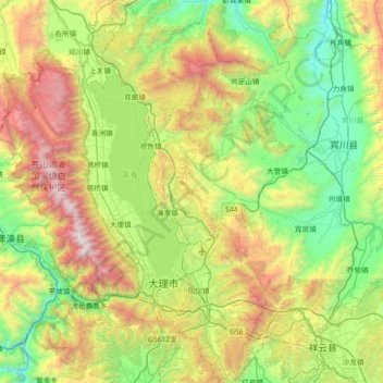
Name: Dali City topographic map, elevation, terrain.
Location: Dali City, Dali Bai Autonomous Prefecture, Yunnan, China (25.42414 99.97843 26.07829 100.43644)
Average elevation: 7,126 ft
Minimum elevation: 4,209 ft
Maximum elevation: 13,327 ft
Make a donation
Gear up for your next adventure:
As an Amazon Associate, this site earns from qualifying purchases at no extra cost to you.
Other topographic maps
Click on a map to view its topography, its elevation and its terrain.
Make a donation
Gear up for your next adventure:
As an Amazon Associate, this site earns from qualifying purchases at no extra cost to you.
Tengchong
Situated at the southwestern end of the (transversely faulted) Hengduan Mountains, Tengchong topographically assumes the form of a horseshoe with the opening facing the south. The easternmost sources of the Irrawaddy River issue from the high mountains at the summit of Mount Danaozi of Gaoligong Mountain,…
Average elevation: 5,807 ft
Yuanyang
China > Yunnan > Yuanyang County
It covers an area of 2,200 km2 (850 sq mi) and has a population of approximately 365,000 (2002), of which 88% belong to ethnic minorities and 95% is associated with agriculture. The majority of the inhabitants of the county are from the Hani ethnic group. The GDP of Yuanyang county in 2021 was 9,312 million…
Average elevation: 3,842 ft
Make a donation
Gear up for your next adventure:
As an Amazon Associate, this site earns from qualifying purchases at no extra cost to you.
Baihetan Dam
China > Yunnan > Qiaojia County > Zhaotong City > Dazhai
The Baihetan Dam (simplified Chinese: 白鹤滩大坝; traditional Chinese: 白鶴灘大壩; pinyin: Báihètān Dàbà) is a large hydroelectric dam on the Jinsha River, an upper stretch of the Yangtze River in Sichuan and Yunnan provinces, in southwest China. The dam is a 289-meter-tall double-curvature arch…
Average elevation: 3,481 ft
Jade Dragon Snow Mountain
China > Yunnan > Lijiang City
The view of the massif from the gardens at the Black Dragon Pool (Heilong Tan) in Lijiang is noted as one of China's finest views. The mountain is part of Yulong Snow Mountain National Scenic Area and National Geological Park, an AAAAA-classified scenic area. The Park operates a tourist cable car that climbs…
Average elevation: 15,843 ft
Make a donation
Gear up for your next adventure:
As an Amazon Associate, this site earns from qualifying purchases at no extra cost to you.
Make a donation
Gear up for your next adventure:
As an Amazon Associate, this site earns from qualifying purchases at no extra cost to you.
Make a donation
Gear up for your next adventure:
As an Amazon Associate, this site earns from qualifying purchases at no extra cost to you.
Make a donation
Gear up for your next adventure:
As an Amazon Associate, this site earns from qualifying purchases at no extra cost to you.
Shilin Stone Forest Landscape District
China > Yunnan > Shilin Yi Autonomous County > Kunming
The strata are part of a gentle (2-6 degree) westward dipping monocline. Conjugate shear joints (NE-SW and NE-SE) are well developed and these fractures provided the main passageways for surface and underground water in the pre-karst development stage. The distribution, density and orientation of the fractures…
Average elevation: 5,797 ft
Make a donation
Gear up for your next adventure:
As an Amazon Associate, this site earns from qualifying purchases at no extra cost to you.
Make a donation
Gear up for your next adventure:
As an Amazon Associate, this site earns from qualifying purchases at no extra cost to you.
Make a donation
Gear up for your next adventure:
As an Amazon Associate, this site earns from qualifying purchases at no extra cost to you.
Make a donation
Gear up for your next adventure:
As an Amazon Associate, this site earns from qualifying purchases at no extra cost to you.
Napahai Nature Reserve
China > Yunnan > Shangri-La > Jiantang > Chui Zongdala
Average elevation: 11,188 ft
Make a donation
Gear up for your next adventure:
As an Amazon Associate, this site earns from qualifying purchases at no extra cost to you.
Make a donation
Gear up for your next adventure:
As an Amazon Associate, this site earns from qualifying purchases at no extra cost to you.
Make a donation
Gear up for your next adventure:
As an Amazon Associate, this site earns from qualifying purchases at no extra cost to you.
Zhenyuan
China > Yunnan > Zhenyuan Yi, Hani and Lahu Autonomous County > Enle
Average elevation: 5,128 ft
Make a donation
Gear up for your next adventure:
As an Amazon Associate, this site earns from qualifying purchases at no extra cost to you.
Make a donation
Gear up for your next adventure:
As an Amazon Associate, this site earns from qualifying purchases at no extra cost to you.
Make a donation
Gear up for your next adventure:
As an Amazon Associate, this site earns from qualifying purchases at no extra cost to you.