
Saitama topographic map
Interactive map
Click on the map to display elevation.
About this map
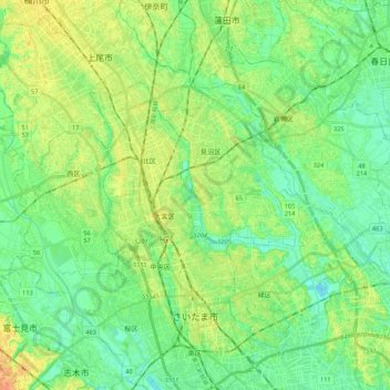
Name: Saitama topographic map, elevation, terrain.
Location: Saitama, Saitama Prefecture, Japan (35.82859 139.54604 36.00269 139.75734)
Average elevation: 43 ft
Minimum elevation: 0 ft
Maximum elevation: 105 ft
The city is located 20 to 30 km north of central Tokyo, roughly at the center of the Kantō Plain. Situated in the southeast of Saitama Prefecture, the city is topographically comprised by lowlands and plateaus, at mostly less than 20 m above sea level, with no mountain ranges or hills within the city boundaries. The western portion of the city lies on the lowland created by the Arakawa River along with those created by small rivers such as the Moto-Arakawa River, Shiba River, and Ayase River. The rest of the area mostly resides on the Ōmiya Plateau lying in the north-south direction. Dispersed in this region, major rivers flow southward, almost paralleling to one another.
Other topographic maps
Click on a map to view its topography, its elevation and its terrain.
Ozora
Ozora, Abashiri County, Okhotsk Subprefecture, Hokkaido Prefecture, Japan
Average elevation: 371 ft
Biratori
Biratori, Saru County, Hidaka Subprefecture, Hokkaido Prefecture, Japan
Average elevation: 607 ft
Toshima Island
Toshima Island, Maizuru, Kyoto Prefecture, Japan
Average elevation: 69 ft
Niseko
Niseko, Abuta County, Shiribeshi Subprefecture, Hokkaido Prefecture, Japan
Average elevation: 1,112 ft
Nichinan
Nichinan, Hino County, Tottori Prefecture, Japan
Average elevation: 1,906 ft
Noto
Noto, Houshi County, Ishikawa Prefecture, Chubu Region, Japan
Average elevation: 184 ft
Kitanakagusuku
Kitanakagusuku, Nakagami, Okinawa Prefecture, Japan
Average elevation: 194 ft
Arita
Arita, Nishi-Matsuura County, Saga Prefecture, Japan
Average elevation: 604 ft
Watarase Usuichi
Watarase Usuichi, Tochigi, Tochigi Prefecture, 374-0112, Japan
Average elevation: 59 ft
Hakone
Hakone, Ashigarashimo County, Kanagawa Prefecture, Japan
Average elevation: 2,369 ft
Minakami
Minakami, Tone County, Gunma Prefecture, Japan
Average elevation: 3,350 ft
Saza
Saza, Kita-Matsuura County, Nagasaki Prefecture, 857-0322, Japan
Average elevation: 364 ft
Sagara
Sagara, Kuma County, Kumamoto Prefecture, 868-0094, Japan
Average elevation: 1,385 ft
Nakaniikawa County
Nakaniikawa County, Toyama Prefecture, Chubu Region, Japan
Average elevation: 2,182 ft