
Victoria topographic map
Click on the map to display elevation.
Victoria
Victoria, British Columbia, is situated on the southern tip of Vancouver Island, Canada, and boasts a diverse and varied topography. The city is characterized by rolling hills, rugged coastal cliffs, and lush valleys, providing a striking contrast between mountainous terrain and flatland areas. To the north and west, the land gradually rises into the Saanich Peninsula and the Malahat mountain range, with steep slopes offering spectacular views of the surrounding coastline. Victoria's landscape is further shaped by its proximity to the Pacific Ocean, with rocky shorelines, tidal flats, and sheltered coves. The region also features several parks and green spaces, including the famous Butchart Gardens, where the landscape’s natural beauty is complemented by human-crafted gardens. This coastal and mountainous terrain makes Victoria a unique blend of wilderness and urban charm.
About this map
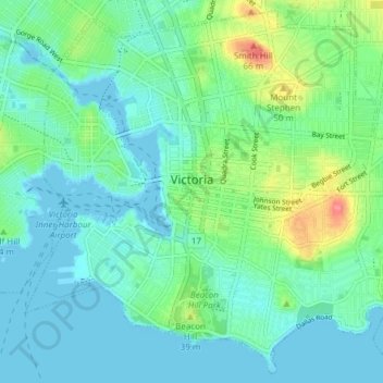
Name: Victoria topographic map, elevation, terrain.
Average elevation: 56 ft
Minimum elevation: -3 ft
Maximum elevation: 246 ft
Other topographic maps
Click on a map to view its topography, its elevation and its terrain.
Lone Tree Hill
Canada > British Columbia > Capital Regional District > Highlands
Average elevation: 751 ft
Mount Douglas
Canada > British Columbia > Capital Regional District > Saanich
Average elevation: 154 ft
Port Renfrew
Canada > British Columbia > Capital Regional District > Juan de Fuca Electoral Area
Average elevation: 256 ft
Leechtown
Canada > British Columbia > Capital Regional District > Juan de Fuca Electoral Area
Average elevation: 778 ft
San Juan River
Canada > British Columbia > Capital Regional District > Juan de Fuca Electoral Area
Average elevation: 121 ft
Shirley
Canada > British Columbia > Capital Regional District > Juan de Fuca Electoral Area
Average elevation: 259 ft
San Juan Ridge
Canada > British Columbia > Capital Regional District > Juan de Fuca Electoral Area
Average elevation: 2,759 ft
Saanich Peninsula
Canada > British Columbia > Capital Regional District > Central Saanich
Average elevation: 161 ft
Ganges
Canada > British Columbia > Capital Regional District > Salt Spring Island Electoral Area
Average elevation: 371 ft
Saanich
Canada > British Columbia > Capital Regional District > Saanich > Saanich
Average elevation: 105 ft
Esquimalt
Canada > British Columbia > Capital Regional District > Esquimalt > Esquimalt
Average elevation: 46 ft
Brailsford Park
Canada > British Columbia > Capital Regional District > Sooke
Average elevation: 266 ft
Mount Tolmie
Canada > British Columbia > Capital Regional District > Saanich
Average elevation: 171 ft
View Royal
Canada > British Columbia > Capital Regional District > View Royal > View Royal
Average elevation: 112 ft
Fulford Harbour
Canada > British Columbia > Capital Regional District > Salt Spring Island Electoral Area
Average elevation: 361 ft
Triangular Hill
Canada > British Columbia > Capital Regional District > Colwood
Average elevation: 354 ft
Maltwood Park
Canada > British Columbia > Capital Regional District > Saanich
Average elevation: 125 ft
PKOLS (Mount Douglas)
Canada > British Columbia > Capital Regional District > Saanich
Average elevation: 154 ft
Mount Finlayson
Canada > British Columbia > Capital Regional District > Langford
Average elevation: 518 ft
Japan Gulch Reservoir
Canada > British Columbia > Capital Regional District > Juan de Fuca Electoral Area
Average elevation: 899 ft
Mayne
Canada > British Columbia > Capital Regional District > Southern Gulf Islands Electoral Area
Average elevation: 171 ft
Goldstream River
Canada > British Columbia > Capital Regional District > Juan de Fuca Electoral Area
Average elevation: 810 ft
Cecelia Creek Falls Park
Canada > British Columbia > Capital Regional District > Saanich
Average elevation: 118 ft
Mount Parke
Canada > British Columbia > Capital Regional District > Southern Gulf Islands Electoral Area
Average elevation: 243 ft
Abraham Collins' Lookout
Canada > British Columbia > Capital Regional District > North Saanich
Average elevation: 489 ft
Young Lake
Canada > British Columbia > Capital Regional District > Juan de Fuca Electoral Area
Average elevation: 453 ft
Galiano
Canada > British Columbia > Capital Regional District > Southern Gulf Islands Electoral Area
Average elevation: 269 ft
Mayne
Canada > British Columbia > Capital Regional District > Southern Gulf Islands Electoral Area
Average elevation: 171 ft
Crow's Nest
Canada > British Columbia > Capital Regional District > Metchosin
Average elevation: 1,001 ft
Mayne
Canada > British Columbia > Capital Regional District > Southern Gulf Islands Electoral Area
Average elevation: 171 ft