
North Cascades National Park topographic map
Interactive map
Click on the map to display elevation.
About this map
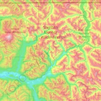
Name: North Cascades National Park topographic map, elevation, terrain.
Average elevation: 3,773 ft
Minimum elevation: 112 ft
Maximum elevation: 10,722 ft
Other topographic maps
Click on a map to view its topography, its elevation and its terrain.
Bellingham
United States > Washington > Whatcom County
Bellingham, Whatcom County, Washington, United States
Average elevation: 292 ft
Mount Herman
United States > Washington > Whatcom County
Mount Herman, Whatcom County, Washington, United States
Average elevation: 4,803 ft
Ferndale
United States > Washington > Whatcom County
Ferndale, Whatcom County, Washington, United States
Average elevation: 95 ft
Mount Baker
United States > Washington > Whatcom County
Mount Baker, Whatcom County, Washington, United States
Average elevation: 8,855 ft
Lummi Nation Community Park
United States > Washington > Whatcom County
Lummi Nation Community Park, Whatcom County, Washington, United States
Average elevation: 10 ft
Blaine
United States > Washington > Whatcom County
Blaine, Whatcom County, Washington, 98231, United States
Average elevation: 75 ft
Sudden Valley
United States > Washington > Whatcom County
Sudden Valley, Whatcom County, Washington, United States
Average elevation: 784 ft
Rome
United States > Washington > Whatcom County
Rome, Whatcom County, Washington, United States
Average elevation: 466 ft
Point Roberts
United States > Washington > Whatcom County > Point Roberts
Point Roberts, Whatcom County, Washington, 98281, United States
Average elevation: 30 ft
Birch Bay
United States > Washington > Whatcom County > Birch Bay
Birch Bay, Whatcom County, Washington, 98230, United States
Average elevation: 36 ft
Marietta
United States > Washington > Whatcom County
Marietta, Whatcom County, Washington, 99248, United States
Average elevation: 33 ft
Lake Whatcom
United States > Washington > Whatcom County > Sudden Valley
Lake Whatcom, Sudden Valley, Whatcom County, Washington, United States
Average elevation: 1,283 ft
Whatcom Falls Park
United States > Washington > Whatcom County > Bellingham
Whatcom Falls Park, Bellingham, Whatcom County, Washington, United States
Average elevation: 246 ft
Chuckanut Mountain
United States > Washington > Whatcom County
Chuckanut Mountain, Whatcom County, Washington, United States
Average elevation: 1,079 ft
Bellingham
United States > Washington > Whatcom County > Bellingham
Bellingham, Whatcom County, Washington, 98225-3243, United States
Average elevation: 423 ft
Pine Lake Wildlife Area
United States > Washington > Whatcom County
Pine Lake Wildlife Area, Pine and Cedar Lakes Trail, Whatcom County, Washington, United States
Average elevation: 1,175 ft
Maple Falls
United States > Washington > Whatcom County
Maple Falls, Whatcom County, Washington, United States
Average elevation: 1,450 ft
Lynden
United States > Washington > Whatcom County
Lynden, Whatcom County, Washington, United States
Average elevation: 85 ft
Custer
United States > Washington > Whatcom County
Custer, Whatcom County, Washington, 98240, United States
Average elevation: 66 ft
Birch Bay
United States > Washington > Whatcom County
Birch Bay, Whatcom County, Washington, 98230, United States
Average elevation: 69 ft
Acme
United States > Washington > Whatcom County
Acme, Whatcom County, Washington, 98220, United States
Average elevation: 1,378 ft
Everson
United States > Washington > Whatcom County
Everson, Whatcom County, Washington, United States
Average elevation: 92 ft
Mount Redoubt
United States > Washington > Whatcom County
Mount Redoubt, Whatcom County, Washington, United States
Average elevation: 6,827 ft
Sumas
United States > Washington > Whatcom County
Sumas, Whatcom County, Washington, 98295, United States
Average elevation: 49 ft
Ross Lake
United States > Washington > Whatcom County
Ross Lake, Whatcom County, Washington, United States
Average elevation: 4,311 ft
Hampton
United States > Washington > Whatcom County > Hampton
Hampton, Whatcom County, Washington, 98276, United States
Average elevation: 79 ft
Lummi Island
United States > Washington > Whatcom County
Lummi Island, Whatcom County, Washington, United States
Average elevation: 79 ft
Deming
United States > Washington > Whatcom County
Deming, Whatcom County, Washington, United States
Average elevation: 899 ft
Newhalem
United States > Washington > Whatcom County > Newhalem
Newhalem, Whatcom County, Washington, United States
Average elevation: 1,614 ft
Diablo
United States > Washington > Whatcom County
Diablo, Whatcom County, Washington, United States
Average elevation: 2,136 ft
Mount Shuksan
United States > Washington > Whatcom County
Mount Shuksan, Whatcom County, Washington, United States
Average elevation: 6,978 ft