
Make a donation
Gear up for your next adventure:
As an Amazon Associate, this site earns from qualifying purchases at no extra cost to you.
格勒 topographic map
Click on the map to display elevation.
Make a donation
Gear up for your next adventure:
As an Amazon Associate, this site earns from qualifying purchases at no extra cost to you.
About this map
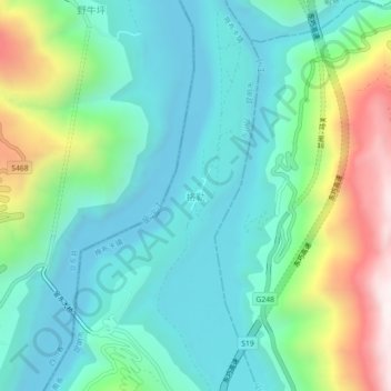
Name: 格勒 topographic map, elevation, terrain.
Location: 格勒, 昆明市, 云南省, 中国 (26.50021 103.03481 26.54021 103.07481)
Average elevation: 3,159 ft
Minimum elevation: 2,277 ft
Maximum elevation: 5,604 ft
Make a donation
Gear up for your next adventure:
As an Amazon Associate, this site earns from qualifying purchases at no extra cost to you.
Other topographic maps
Click on a map to view its topography, its elevation and its terrain.
Make a donation
Gear up for your next adventure:
As an Amazon Associate, this site earns from qualifying purchases at no extra cost to you.
石林彝族自治县
石林彝族自治县位于滇东高原南部,地势东高西低,起伏平缓,地形以山地、丘陵为主,分别占全县面积的69%和15.2%,坝区占14.70%。最高点是东部老圭山主峰,海拔2,601米,最低点为西部巴江出境处,海拔1,500米,县城鹿阜海拔1,668米。石林县境的地势自东向西倾斜,呈三级阶梯分布,东、中、西依次为老圭山、九蟠山、路南坝地区。县内的山脉属云岭余脉,多为南北走向,主要有老圭山、九蟠山、打羊山、大佛山等。山脉主要分布于东部、中部、西北部及西部边界处,受河流切割形成相对高山深谷的地貌。全县按照地貌类型,又可分为东南部西北部山地、巴江盆地(即路南坝)和中部岩溶地区。
Average elevation: 6,175 ft
Make a donation
Gear up for your next adventure:
As an Amazon Associate, this site earns from qualifying purchases at no extra cost to you.
Make a donation
Gear up for your next adventure:
As an Amazon Associate, this site earns from qualifying purchases at no extra cost to you.
Make a donation
Gear up for your next adventure:
As an Amazon Associate, this site earns from qualifying purchases at no extra cost to you.
Make a donation
Gear up for your next adventure:
As an Amazon Associate, this site earns from qualifying purchases at no extra cost to you.
Make a donation
Gear up for your next adventure:
As an Amazon Associate, this site earns from qualifying purchases at no extra cost to you.