
官渡区 topographic map
Interactive map
Click on the map to display elevation.
About this map
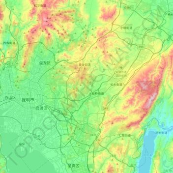
Name: 官渡区 topographic map, elevation, terrain.
Location: 官渡区, 昆明市, 云南省, 中国 (24.87127 102.66252 25.25751 103.04727)
Average elevation: 6,680 ft
Minimum elevation: 5,778 ft
Maximum elevation: 8,875 ft
Other topographic maps
Click on a map to view its topography, its elevation and its terrain.