
Diamond Springs topographic map
Click on the map to display elevation.
Diamond Springs
Diamond Springs (formerly, Diamond Spring and Diamond) is a census-designated place (CDP) in El Dorado County, California, United States. It is part of the Sacramento–Arden-Arcade–Roseville Metropolitan Statistical Area. The population was 11,037 at the 2010 census, up from 4,888 at the 2000 census. The town is registered as California Historical Landmark number 487. It lies at an elevation of 1791 feet (546 m).
About this map
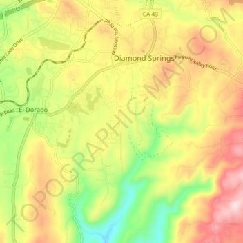
Name: Diamond Springs topographic map, elevation, terrain.
Average elevation: 1,742 ft
Minimum elevation: 1,145 ft
Maximum elevation: 2,333 ft
El Dorado County trails, hiking, mountain biking, running and outdoor activities
Other topographic maps
Click on a map to view its topography, its elevation and its terrain.
El Dorado
United States > California > El Dorado County
El Dorado (Spanish for "The Golden") is an unincorporated community in El Dorado County, California. It is located 4 miles (6.4 km) southwest of Placerville, at an elevation of 1608 feet (490 m). The population was 4,096 at the 2000 census. The town is registered as California Historical Landmark #486. The ZIP…
Average elevation: 1,677 ft
Cameron Park
United States > California > El Dorado County
Cameron Park is situated in an interior chaparral zone or brush zone just east of the Central Valley. It is the closest population center to the Pine Hill Ecological Reserve. Native vegetation includes an abundance of redbud and manzanita bushes, and brush in general. Where treed the native trees are primarily…
Average elevation: 1,280 ft
Fallen Leaf Lake
United States > California > El Dorado County
The surface elevation of the lake is 152 feet (46 m) above Lake Tahoe.
Average elevation: 6,785 ft
Pollock Pines
United States > California > El Dorado County
Pollock Pines is a census-designated place (CDP) in El Dorado County, California, United States. It is part of the Sacramento–Arden-Arcade–Roseville Metropolitan Statistical Area. Pollock Pines lies at an elevation of 3,980 feet (1,210 m) in the Sierra Nevada. The population was 6,871 at the 2010 census,…
Average elevation: 3,681 ft
South Lake Tahoe
United States > California > El Dorado County > South Lake Tahoe > South Lake Tahoe
Average elevation: 6,378 ft
South Lake Tahoe-El Dorado Recreation Area
United States > California > El Dorado County > South Lake Tahoe > Bijou
Average elevation: 6,250 ft
El Dorado Hills
United States > California > El Dorado County > Folsom
El Dorado Hills (EDH), as defined by the 2010 census-designated place (CDP), is at the western border of El Dorado County, between the City of Folsom and the unincorporated community of Cameron Park. The northern limits of the CDP are Folsom Lake and the South Fork of the American River, where river rafters…
Average elevation: 797 ft
Diamond Springs
United States > California > El Dorado County
Diamond Springs (formerly, Diamond Spring and Diamond) is a census-designated place (CDP) in El Dorado County, California, United States. It is part of the Sacramento–Arden-Arcade–Roseville Metropolitan Statistical Area. The population was 11,037 at the 2010 census, up from 4,888 at the 2000 census. The…
Average elevation: 1,742 ft
Bridlewood Canyon
United States > California > El Dorado County > Cameron Park
Average elevation: 1,234 ft
Laurel Oaks Park
United States > California > El Dorado County > Cameron Park > Bar J Ranch
Average elevation: 1,247 ft
Kingsville
United States > California > El Dorado County
Kingsville (formerly, Kingville) is an unincorporated community in El Dorado County, California. It is located 5 miles (8 km) southwest of Placerville, at an elevation of 1532 feet (467 m).
Average elevation: 1,552 ft
Stateline
United States > California > El Dorado County > South Lake Tahoe
Average elevation: 6,490 ft
Cameron Airpark Estates
United States > California > El Dorado County > Cameron Park
Average elevation: 1,348 ft
Tallac Village
United States > California > El Dorado County > South Lake Tahoe
Average elevation: 6,381 ft
Tahoe Keys
United States > California > El Dorado County > South Lake Tahoe
Average elevation: 6,542 ft
Tahoe Valley
United States > California > El Dorado County > South Lake Tahoe
Average elevation: 6,348 ft
Cambridge Oaks
United States > California > El Dorado County > Cameron Park
Average elevation: 1,234 ft
Echo Summit
United States > California > El Dorado County
Echo Summit is notable for being the location (sometimes listed as "South Lake Tahoe") of the 1968 U.S. Olympic track and field trials for men, held September 6–16, a month before the 1968 Olympics in Mexico City. (The women's trials were at low altitude in Los Angeles County, at Walnut.) The Echo Summit…
Average elevation: 7,218 ft