
Make a donation
Gear up for your next adventure:
As an Amazon Associate, this site earns from qualifying purchases at no extra cost to you.
Peñamellera Baja topographic map
Click on the map to display elevation.
Make a donation
Gear up for your next adventure:
As an Amazon Associate, this site earns from qualifying purchases at no extra cost to you.
About this map
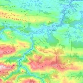
Name: Peñamellera Baja topographic map, elevation, terrain.
Location: Peñamellera Baja, Asturias, Spain (43.26395 -4.70604 43.35115 -4.51857)
Average elevation: 1,378 ft
Minimum elevation: 0 ft
Maximum elevation: 4,711 ft
Make a donation
Gear up for your next adventure:
As an Amazon Associate, this site earns from qualifying purchases at no extra cost to you.
Other topographic maps
Click on a map to view its topography, its elevation and its terrain.
Make a donation
Gear up for your next adventure:
As an Amazon Associate, this site earns from qualifying purchases at no extra cost to you.
Make a donation
Gear up for your next adventure:
As an Amazon Associate, this site earns from qualifying purchases at no extra cost to you.
Bulnes de Arriba (El Castillo)
Spain > Asturias > Cabrales > Bulnes de Arriba (El Castillo)
Average elevation: 3,734 ft
Make a donation
Gear up for your next adventure:
As an Amazon Associate, this site earns from qualifying purchases at no extra cost to you.
Arriondas / Les Arriondes
Spain > Asturias > Parres > Arriondas / Les Arriondes
Average elevation: 614 ft
Make a donation
Gear up for your next adventure:
As an Amazon Associate, this site earns from qualifying purchases at no extra cost to you.