
Schonstett topographic map
Click on the map to display elevation.
Schonstett
Der Codex diplomaticus Falkensteinensis erwähnt Schonstett als Sconsteten, später auch als Sconstet, in späteren Dokumenten des Klosters Herrenchiemsee aus dem 12. Jahrhundert findet sich Schônstete. Im hohen Mittelalter waren die Herren von Schonstett Dienstmannen der Hallgrafen von Wasserburg am Inn. In der Mitte des 15. Jahrhunderts wird die Höhenburg aufgegeben und 1480 ein Wasserschloss errichtet. Dies wurde um 1700 von Michael Wening abgebildet und ist bis heute weitgehend unverändert. Allerdings wurde der Wassergraben im 19. Jahrhundert zugefüllt.
About this map
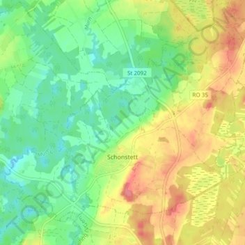
Name: Schonstett topographic map, elevation, terrain.
Average elevation: 1,565 ft
Minimum elevation: 1,463 ft
Maximum elevation: 1,706 ft
Other topographic maps
Click on a map to view its topography, its elevation and its terrain.
Kampenwand-Hauptgipfel
Deutschland > Bayern > Landkreis Rosenheim > Aschau im Chiemgau
Average elevation: 4,173 ft
Falkenstein
Deutschland > Bayern > Landkreis Rosenheim > Flintsbach am Inn
Average elevation: 2,014 ft
Großhöhenrain
Deutschland > Bayern > Landkreis Rosenheim > Feldkirchen-Westerham
Average elevation: 1,864 ft
Hochrunstfilze
Deutschland > Bayern > Landkreis Rosenheim > Raubling > Nicklheim
Average elevation: 1,535 ft
Staffelstein
Deutschland > Bayern > Landkreis Rosenheim > Aschau im Chiemgau
Average elevation: 4,127 ft
Thalham
Deutschland > Bayern > Landkreis Rosenheim > Bruckmühl > Mittenkirchen
Average elevation: 1,765 ft
Geigelstein
Deutschland > Bayern > Landkreis Rosenheim > Aschau im Chiemgau
1991 wurden große Flächen des Geigelstein als Naturschutzgebiet Geigelstein ausgewiesen. Das NSG Geigelstein hat eine Größe von 3135 Hektar und liegt zum Teil im Landkreis Rosenheim mit der Gemeinde Aschau sowie im Landkreis Traunstein mit der Gemeinde Schleching. Mit einem der größten Schutzgebiete auf…
Average elevation: 4,734 ft
Wasserburg am Inn
Deutschland > Bayern > Landkreis Rosenheim > Wasserburg am Inn > Wasserburg am Inn
Average elevation: 1,565 ft
Bad Feilnbach
Deutschland > Bayern > Landkreis Rosenheim > Bad Feilnbach > Bad Feilnbach
Average elevation: 2,162 ft
Hohenaschau
Deutschland > Bayern > Landkreis Rosenheim
Aschach | Aschau im Chiemgau | Attich | Aufham | Außerkoy | Außerwald | Bach | Berg | Brückl | Bucha | Einfang | Engerndorf | Fellerer | Göttersberg | Grattenbach | Grenzhub | Grünwald | Hainbach | Haindorf | Hammerbach | Hintergschwendt | Hohenaschau im Chiemgau | Höhenberg | Hub | Huben | Innerkoy |…
Average elevation: 2,831 ft
Hochries
Deutschland > Bayern > Landkreis Rosenheim > Samerberg
Der Gipfel ist per Bahn von Grainbach aus zu erreichen. Vom Ort geht ein Sessellift zur Mittelstation auf 920 m Höhe. Von dort führt eine Kabinenbahn auf den Gipfel. Die Hochries ist als Rosenheimer „Hausberg“ beliebt bei Wanderern sowie insbesondere Gleitschirm- und Drachenfliegern.
Average elevation: 4,012 ft
Elend
Deutschland > Bayern > Landkreis Rosenheim > Wasserburg am Inn > Attel
Average elevation: 1,476 ft
Vagen
Deutschland > Bayern > Landkreis Rosenheim > Feldkirchen-Westerham
Vagen ist ein Ortsteil der Gemeinde Feldkirchen-Westerham im Landkreis Rosenheim. Das Pfarrdorf liegt auf einer Höhe von 525,7 m ü. NN. Vor der Gemeindegebietsreform 1972 war Vagen eine eigenständige Gemeinde.
Average elevation: 1,850 ft
Kleiner Traithen
Deutschland > Bayern > Landkreis Rosenheim > Kiefersfelden
Average elevation: 4,383 ft
Aich
Deutschland > Bayern > Landkreis Rosenheim > Raubling > Großholzhausen
Average elevation: 1,542 ft
Westerham
Deutschland > Bayern > Landkreis Rosenheim > Feldkirchen-Westerham
Average elevation: 1,909 ft
Hammerbach
Deutschland > Bayern > Landkreis Rosenheim > Aschau im Chiemgau
Average elevation: 2,858 ft
Unterlaus
Deutschland > Bayern > Landkreis Rosenheim > Feldkirchen-Westerham
Average elevation: 1,926 ft
Urschalling
Deutschland > Bayern > Landkreis Rosenheim > Prien am Chiemsee > Bach
Average elevation: 1,847 ft
Fachendorf
Deutschland > Bayern > Landkreis Rosenheim > Bad Aibling > Berbling
Average elevation: 1,729 ft
Kleinhöhenrain
Deutschland > Bayern > Landkreis Rosenheim > Feldkirchen-Westerham > Großhöhenrain
Average elevation: 1,841 ft
Stetten
Deutschland > Bayern > Landkreis Rosenheim > Prien am Chiemsee > Atzing
Average elevation: 1,913 ft
Feldolling
Deutschland > Bayern > Landkreis Rosenheim > Feldkirchen-Westerham
Average elevation: 1,837 ft
Happinger See
Deutschland > Bayern > Landkreis Rosenheim > Rosenheim > Pfraundorf
Average elevation: 1,480 ft
Siegharting
Deutschland > Bayern > Landkreis Rosenheim > Prien am Chiemsee
Average elevation: 1,972 ft
Kleinholzhausen
Deutschland > Bayern > Landkreis Rosenheim > Raubling > Großholzhausen
Average elevation: 1,660 ft