
Make a donation
Gear up for your next adventure:
As an Amazon Associate, this site earns from qualifying purchases at no extra cost to you.
Varnell topographic map
Click on the map to display elevation.
Make a donation
Gear up for your next adventure:
As an Amazon Associate, this site earns from qualifying purchases at no extra cost to you.
About this map
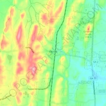
Name: Varnell topographic map, elevation, terrain.
Location: Varnell, Whitfield County, Georgia, 30756, United States (34.87136 -84.99511 34.92840 -84.91662)
Average elevation: 883 ft
Minimum elevation: 709 ft
Maximum elevation: 1,138 ft
Whitfield County trails, hiking, mountain biking, running and outdoor activities
Make a donation
Gear up for your next adventure:
As an Amazon Associate, this site earns from qualifying purchases at no extra cost to you.
Other topographic maps
Click on a map to view its topography, its elevation and its terrain.
Potato Hill Civil War Battlefield Park
United States > Georgia > Whitfield County > Dalton
Average elevation: 843 ft
Make a donation
Gear up for your next adventure:
As an Amazon Associate, this site earns from qualifying purchases at no extra cost to you.