Geolocate

Hammerfest topographic map

Click on the map to display elevation.

About this map

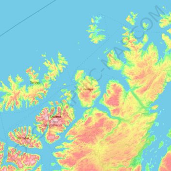
Name: Hammerfest topographic map, elevation, terrain.

Location: Hammerfest, Troms og Finnmark, Norway (70.09652 22.29834 71.18623 24.97721)

Average elevation: 459 ft

Minimum elevation: -16 ft

Maximum elevation: 3,428 ft

Other topographic maps

Click on a map to view its topography, its elevation and its terrain.

Alta

Norway > Troms og Finnmark

Average elevation: 112 ft

Skjolden

Norway > Troms og Finnmark > Sørvær

Average elevation: 410 ft

Bjørnevatn

Norway > Troms og Finnmark

Average elevation: 269 ft

Dyrstad

Norway > Troms og Finnmark

Average elevation: 203 ft

Máze - Masi

Norway > Troms og Finnmark

Average elevation: 1,165 ft

Setermoen

Norway > Troms og Finnmark > Setermoen

Average elevation: 407 ft

Roavvegieddi

Norway > Troms og Finnmark

Average elevation: 512 ft

Laksvatn

Norway > Troms og Finnmark

Average elevation: 699 ft

Moen

Norway > Troms og Finnmark

Average elevation: 328 ft

Gear up for your next adventure:

🗺️NatGeo Topo Maps - High-quality waterproof printed topographic maps of US Parks
🎒Day Hiking Backpack - Lightweight backpack perfect for day trips and outdoor adventures
📷Action Cameras - Rugged cameras to document your journeys across rugged terrain
🥾Women's Hiking Boots - Top-rated trail boots with ankle support and superior grip
🦟Ultrasonic Repellers - Create a bug-free zone at your camp or rest stop

As an Amazon Associate, this site earns from qualifying purchases at no extra cost to you.