
Make a donation
Gear up for your next adventure:
As an Amazon Associate, this site earns from qualifying purchases at no extra cost to you.
San Marcos topographic map
Click on the map to display elevation.
Make a donation
Gear up for your next adventure:
As an Amazon Associate, this site earns from qualifying purchases at no extra cost to you.
San Marcos
The climate varies widely within the department, due to the dramatic differences in altitude, with the north possessing a cold Guatemalan Highlands climate and the south having a temperate or hot climate, depending on the specific altitude.
Make a donation
Gear up for your next adventure:
As an Amazon Associate, this site earns from qualifying purchases at no extra cost to you.
About this map
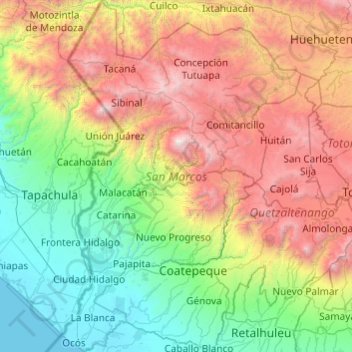
Name: San Marcos topographic map, elevation, terrain.
Location: San Marcos, Guatemala (14.48489 -92.22825 15.42140 -91.56852)
Average elevation: 4,413 ft
Minimum elevation: -3 ft
Maximum elevation: 13,704 ft
Make a donation
Gear up for your next adventure:
As an Amazon Associate, this site earns from qualifying purchases at no extra cost to you.
Other topographic maps
Click on a map to view its topography, its elevation and its terrain.
Make a donation
Gear up for your next adventure:
As an Amazon Associate, this site earns from qualifying purchases at no extra cost to you.
Make a donation
Gear up for your next adventure:
As an Amazon Associate, this site earns from qualifying purchases at no extra cost to you.
Pacaya
Guatemala > Escuintla > San Vicente Pacaya > San Vicente Pacaya > El Cedro
Average elevation: 6,804 ft
Make a donation
Gear up for your next adventure:
As an Amazon Associate, this site earns from qualifying purchases at no extra cost to you.
Make a donation
Gear up for your next adventure:
As an Amazon Associate, this site earns from qualifying purchases at no extra cost to you.
Santa Catarina Pinula
Guatemala > Guatemala Department > Santa Catarina Pinula
Average elevation: 5,187 ft
Make a donation
Gear up for your next adventure:
As an Amazon Associate, this site earns from qualifying purchases at no extra cost to you.
Make a donation
Gear up for your next adventure:
As an Amazon Associate, this site earns from qualifying purchases at no extra cost to you.
Make a donation
Gear up for your next adventure:
As an Amazon Associate, this site earns from qualifying purchases at no extra cost to you.
Santa Cruz del Quiché
Guatemala > Quiché > Santa Cruz del Quiché
Santa Cruz del Quiché is a city, with a population of 78,279 (2018 census), in Guatemala. It serves as the capital of the El Quiché department and the municipal seat of Santa Cruz del Quiché municipality. The city is located at 15°02′N 91°09′W / 15.03°N 91.15°W / 15.03; -91.15, at an…
Average elevation: 6,857 ft
Make a donation
Gear up for your next adventure:
As an Amazon Associate, this site earns from qualifying purchases at no extra cost to you.
Colonia Villa de San Juan
Guatemala > Guatemala Department > Guatemala City
Average elevation: 5,036 ft
Make a donation
Gear up for your next adventure:
As an Amazon Associate, this site earns from qualifying purchases at no extra cost to you.
Make a donation
Gear up for your next adventure:
As an Amazon Associate, this site earns from qualifying purchases at no extra cost to you.
Bosque San Antionio
Guatemala > Chimaltenango > San Juan Comalapa > San Juan Comalapa
Average elevation: 6,972 ft
Make a donation
Gear up for your next adventure:
As an Amazon Associate, this site earns from qualifying purchases at no extra cost to you.
Make a donation
Gear up for your next adventure:
As an Amazon Associate, this site earns from qualifying purchases at no extra cost to you.
Bosque San Antionio
Guatemala > Chimaltenango > San Juan Comalapa > San Juan Comalapa
Average elevation: 6,972 ft
Make a donation
Gear up for your next adventure:
As an Amazon Associate, this site earns from qualifying purchases at no extra cost to you.
San Antonio Suchitepéquez
Guatemala > Suchitepéquez > San Antonio Suchitepéquez
Average elevation: 1,322 ft
Make a donation
Gear up for your next adventure:
As an Amazon Associate, this site earns from qualifying purchases at no extra cost to you.
Make a donation
Gear up for your next adventure:
As an Amazon Associate, this site earns from qualifying purchases at no extra cost to you.
Make a donation
Gear up for your next adventure:
As an Amazon Associate, this site earns from qualifying purchases at no extra cost to you.
Panajachel
Guatemala > Sololá > Panajachel > Panajachel
Panajachel (Spanish pronunciation: , Pana) is a town in the southwestern Guatemalan Highlands, less than 140 kilometres (90 mi) from Guatemala City, in the department of Sololá. It serves as the administrative centre for the surrounding municipality of the same name. The elevation is 1,597 metres (5,240 ft).…
Average elevation: 5,955 ft
Make a donation
Gear up for your next adventure:
As an Amazon Associate, this site earns from qualifying purchases at no extra cost to you.
Make a donation
Gear up for your next adventure:
As an Amazon Associate, this site earns from qualifying purchases at no extra cost to you.
Make a donation
Gear up for your next adventure:
As an Amazon Associate, this site earns from qualifying purchases at no extra cost to you.
Make a donation
Gear up for your next adventure:
As an Amazon Associate, this site earns from qualifying purchases at no extra cost to you.