Geolocate

Mompantero topographic map

Click on the map to display elevation.

About this map

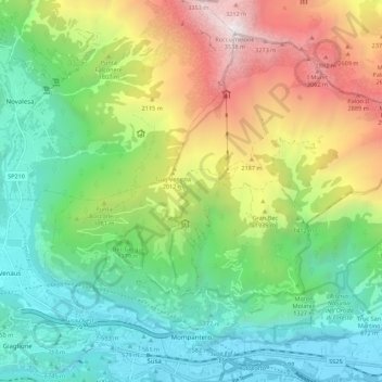
Name: Mompantero topographic map, elevation, terrain.

Location: Mompantero, Torino, Piemont, Italy (45.13962 7.02239 45.20333 7.13179)

Average elevation: 4,908 ft

Minimum elevation: 1,473 ft

Maximum elevation: 11,532 ft

Gear up for your next adventure:

🪶Survival Guide Book - Expert advice for emergency preparedness
👟Men's Trail Runners - Lightweight footwear for fast-paced exploration and light hiking
🩳Quick‑Dry Hiking Shorts - Comfortable and quick‑dry shorts for summer hiking
🪓Survival Multi‑Tool - Versatile tool for camp and trail tasks
🦶Carbon Trekking Poles - Reduce knee impact on steep descents with ultra-light poles

As an Amazon Associate, this site earns from qualifying purchases at no extra cost to you.