Geolocate

Pindra topographic map

Click on the map to display elevation.

About this map

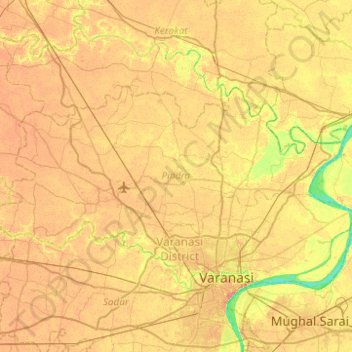
Name: Pindra topographic map, elevation, terrain.

Location: Pindra, Varanasi, Uttar Pradesh, India (25.35023 82.68332 25.57953 83.17786)

Average elevation: 259 ft

Minimum elevation: 177 ft

Maximum elevation: 315 ft

Other topographic maps

Click on a map to view its topography, its elevation and its terrain.

Sravasti

India > Uttar Pradesh > Ikauna

Average elevation: 371 ft

Ralpur Khadar

India > Uttar Pradesh > Noida > Dadri

Average elevation: 653 ft

Firojpur

India > Uttar Pradesh > Moradabad

Average elevation: 692 ft

Chinhat

India > Uttar Pradesh > Lucknow

Average elevation: 384 ft

Lal Kuan

India > Uttar Pradesh > Ghaziabad

Average elevation: 692 ft

Barawa Shukdev

India > Uttar Pradesh > Kasya

Average elevation: 256 ft

Faizabad

India > Uttar Pradesh

Average elevation: 331 ft

Lalitpur

India > Uttar Pradesh

Average elevation: 1,299 ft

Dewal

India > Uttar Pradesh > Zamania

Average elevation: 217 ft

Raebareli

India > Uttar Pradesh > Raebareli

The district forms a part of the Gangetic plain which is of recent origin according to geological chronology and reveal ordinary Gangetic alluvium. The district being a part of the alluvial plain conforms to the same geological sequence as the plain itself. The only mineral of importance is kankar. The…

Average elevation: 364 ft

Meerut

India > Uttar Pradesh

Average elevation: 738 ft

Noida

India > Uttar Pradesh > Dadri

Average elevation: 709 ft

Naini

India > Uttar Pradesh > Karchhana

Average elevation: 292 ft

Govardhan

India > Uttar Pradesh > Mathura

Govardhana is located at 27°30′N 77°28′E / 27.5°N 77.47°E / 27.5; 77.47. It has an average elevation of 179 metres (587 feet). Govardhana has been made Tehsil in Mathura District by the Uttar Pradesh government.

Average elevation: 594 ft

Kamalganj

India > Uttar Pradesh > Farrukhabad

Average elevation: 472 ft

Mirzapur

India > Uttar Pradesh > Mirzapur

Mirzapur is located at 25°09′N 82°35′E / 25.15°N 82.58°E / 25.15; 82.58. It has an average elevation of 80 metres (265 feet). The District of Mirzapur lies between the parallels of 23.52 & 25.32 North latitude and 82.7 and 83.33 East longitude. It forms a portion of the Varanasi district. On…

Average elevation: 272 ft

Shafipur

India > Uttar Pradesh > Shafipur

Average elevation: 643 ft

Dalla

India > Uttar Pradesh > Robertsganj > Dalla

Average elevation: 705 ft

Khudaganj

India > Uttar Pradesh > Tilhar

Average elevation: 531 ft

Miranpur Katra

India > Uttar Pradesh > Tilhar > Miranpur Katra

Average elevation: 522 ft

Nigohi

India > Uttar Pradesh > Tilhar > Nigohi

Average elevation: 525 ft

vegetation

India > Uttar Pradesh > Sirathu

Average elevation: 338 ft

Sahaspur

India > Uttar Pradesh > Dhampur

Sahaspur is located at 29°07′16″N 78°37′16″E / 29.121°N 78.621°E / 29.121; 78.621. It has an average elevation of 199 metres (653 feet).

Average elevation: 712 ft

Chauhan Patti

India > Uttar Pradesh > Kushinagar

Average elevation: 256 ft

Gear up for your next adventure:

🔊Portable Camp Speaker - Music and alerts at camp
🌄Hiking Binoculars - Compact binoculars for scenic views and trail spotting
🛌Ultralight Sleeping Bags - Compact down bags for cold nights in the wilderness
🪑Portable Camp Table - Compact table for campsite meals
🧢Outdoor Hiking Hat - Sun protection hat for outdoor explorers

As an Amazon Associate, this site earns from qualifying purchases at no extra cost to you.