
光泽县 topographic map
Interactive map
Click on the map to display elevation.
About this map
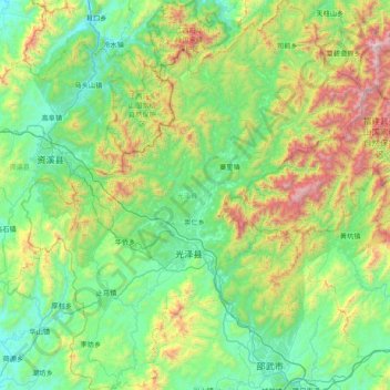
Name: 光泽县 topographic map, elevation, terrain.
Location: 光泽县, 南平市, 福建省, 中国 (27.30404 116.99828 27.98656 117.67614)
Average elevation: 1,886 ft
Minimum elevation: 325 ft
Maximum elevation: 6,811 ft
地形为四周高、中间低,近似由东北向西延伸的平行四边形山间盆地。盆地四周群山连绵,有55座千米以上的高山,东北部地势高。山岭多作北东-南西,或北西-南东走向。从四周向中央逐渐降低,盆地底部较平缓,主要是丘陵、河谷、平原。山地占71.73%、丘陵占18.24%,平原占5.67%,山间盆谷占4.36%。
Other topographic maps
Click on a map to view its topography, its elevation and its terrain.