
Carver County topographic map
Click on the map to display elevation.
About this map
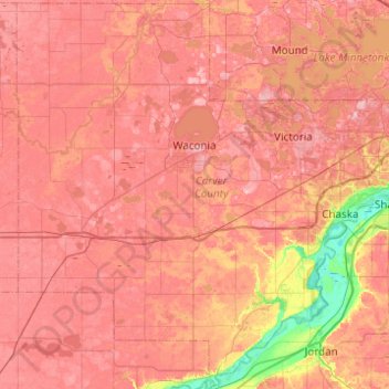
Name: Carver County topographic map, elevation, terrain.
Location: Carver County, Minnesota, United States (44.63456 -94.01233 44.97871 -93.52035)
Average elevation: 948 ft
Minimum elevation: 689 ft
Maximum elevation: 1,083 ft
Minnesota trails, hiking, mountain biking, running and outdoor activities
Other topographic maps
Click on a map to view its topography, its elevation and its terrain.
Ancient River Warren Channel (historical)
United States > Minnesota > Traverse County
Average elevation: 984 ft
Chris Lake
United States > Minnesota > Saint Louis County > Pequaywan Township
Average elevation: 1,621 ft
Big Pine Lake
United States > Minnesota > Pine County > Pine Lake Township
Average elevation: 1,112 ft
Pearl Lake
United States > Minnesota > Stearns County > Maine Prairie Township
Average elevation: 1,125 ft
Elm Creek Park (Maple Grove Arboretum)
United States > Minnesota > Hennepin County > Maple Grove
Average elevation: 912 ft
Eagle Mountain
United States > Minnesota > Cook County > West Cook
Eagle Mountain is only about 12 miles (19 km) from Minnesota's lowest elevation, Lake Superior, at 600 feet (183 m). It is part of the Canadian Shield. There is also another much shorter peak also named Eagle Mountain in northern Minnesota. The shorter peak is part of the Lutsen Mountains ski resort.
Average elevation: 1,955 ft
Embarrass
United States > Minnesota > Saint Louis County > Embarrass Township
Average elevation: 1,437 ft
Grey Cloud Island
United States > Minnesota > Washington County > Grey Cloud Island Township
Average elevation: 738 ft
Riverbend Estates
United States > Minnesota > Nicollet County > North Mankato
Average elevation: 869 ft
St. Croix River Boom Site Landing
United States > Minnesota > Washington County > Stillwater Township
Average elevation: 830 ft
Middle Cullen Lake
United States > Minnesota > Crow Wing County > Pequot Lakes
Average elevation: 1,220 ft
Spencer Lake
United States > Minnesota > Meeker County > Collinwood Township > Jennie
Average elevation: 1,096 ft
Borden Lake
United States > Minnesota > Crow Wing County > Garrison Township
Average elevation: 1,289 ft
Pond-Dakota Mission Park
United States > Minnesota > Hennepin County > Bloomington
Average elevation: 771 ft
Tower Junction
United States > Minnesota > Saint Louis County > Breitung Township > Soudan
Average elevation: 1,434 ft
Inspiration Peak
United States > Minnesota > Otter Tail County > Leaf Mountain Township
Average elevation: 1,493 ft
Burnsville
United States > Minnesota > Dakota County > Burnsville > Burnsville
Average elevation: 902 ft
Norway Creek
United States > Minnesota > Saint Louis County > Northeast St Louis
Average elevation: 1,391 ft
Saint Anna Lake
United States > Minnesota > Stearns County > Krain Township
Average elevation: 1,247 ft
Mississippi River
United States > Minnesota > Hennepin County > Minneapolis
The uppermost lock and dam on the Upper Mississippi River is the Upper St. Anthony Falls Lock and Dam in Minneapolis. Above the dam, the river's elevation is 799 feet (244 m). Below the dam, the river's elevation is 750 feet (230 m). This 49-foot (15 m) drop is the largest of all the Mississippi River locks…
Average elevation: 840 ft
Suburban Mobile Home Park
United States > Minnesota > Morrison County > Little Falls
Average elevation: 1,145 ft
Norway Lake
United States > Minnesota > Kandiyohi County > Arctander Township
Average elevation: 1,217 ft
Silver Bay
United States > Minnesota > Lake County > Silver Bay > Silver Bay
Average elevation: 840 ft
Eden Prairie
United States > Minnesota > Hennepin County > Eden Prairie > Eden Prairie
Average elevation: 876 ft
Rum River North County Park
United States > Minnesota > Anoka County > Saint Francis
Average elevation: 915 ft
Sungold Heights Mobile Home Park
United States > Minnesota > Nobles County > Worthington
Average elevation: 1,581 ft
Central Lakes
United States > Minnesota > Saint Louis County > Ellsburg Township
Average elevation: 1,339 ft
Echo River
United States > Minnesota > Saint Louis County > Northeast St Louis
Average elevation: 1,289 ft
Little Rock Lake
United States > Minnesota > Benton County > Watab Township
Average elevation: 1,056 ft
Moody Lake
United States > Minnesota > Chisago County > Chisago Lake Township
Average elevation: 928 ft