
西彭镇 topographic map
Interactive map
Click on the map to display elevation.
About this map
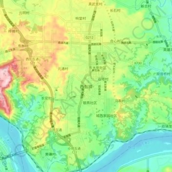
Name: 西彭镇 topographic map, elevation, terrain.
Location: 西彭镇, 九龙坡区, 重庆市, 中国 (29.26571 106.28305 29.34571 106.36305)
Average elevation: 879 ft
Minimum elevation: 545 ft
Maximum elevation: 1,480 ft
西彭镇是中国重庆市九龙坡区下辖的一个镇。海拔高度约300米,地处中梁山脉与缙云山脉之间的槽谷地带南端邻近长江,素有“铝都”之誉。
Other topographic maps
Click on a map to view its topography, its elevation and its terrain.