Geolocate

Heflin topographic map

Click on the map to display elevation.

About this map

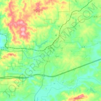
Name: Heflin topographic map, elevation, terrain.

Location: Heflin, Cleburne County, Alabama, United States (33.60966 -85.61629 33.68308 -85.49564)

Average elevation: 991 ft

Minimum elevation: 761 ft

Maximum elevation: 1,385 ft

Cleburne County trails, hiking, mountain biking, running and outdoor activities

Other topographic maps

Click on a map to view its topography, its elevation and its terrain.

Ai

United States > Alabama > Cleburne County

Average elevation: 978 ft

Micaville

United States > Alabama > Cleburne County

Average elevation: 1,181 ft

Trickem

United States > Alabama > Cleburne County

Average elevation: 1,099 ft

Hopewell

United States > Alabama > Cleburne County

Average elevation: 1,073 ft

Liberty Hill

United States > Alabama > Cleburne County

Average elevation: 1,027 ft

Muscadine

United States > Alabama > Cleburne County

Average elevation: 1,014 ft

Abel

United States > Alabama > Cleburne County

Average elevation: 1,004 ft

Abernathy

United States > Alabama > Cleburne County

Average elevation: 971 ft

Chulafinnee

United States > Alabama > Cleburne County

Average elevation: 883 ft

Oak Level

United States > Alabama > Cleburne County > Oak Level

Average elevation: 1,010 ft

Gear up for your next adventure:

🔦LED Headlamp - Bright and durable LED headlamp for night navigation
📱Heavy-Duty Phone Cases - Drop-proof and waterproof protection for outdoor navigation
📚USA Hiking Guide Books - Top trail guides and map books
🔌Solar Panel Charger - Charge gear sustainably outdoors
🌎3D Topographic Globes - Raised relief globes for a tactile understanding of geography

As an Amazon Associate, this site earns from qualifying purchases at no extra cost to you.