Geolocate

K 2 topographic map

Click on the map to display elevation.

About this map

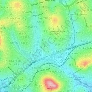
Name: K 2 topographic map, elevation, terrain.

Location: K 2, Kampala, Central Region, Uganda (0.32393 32.60719 0.36393 32.64719)

Average elevation: 3,914 ft

Minimum elevation: 3,753 ft

Maximum elevation: 4,288 ft

Other topographic maps

Click on a map to view its topography, its elevation and its terrain.

Rubaga

Uganda > Central Region > Kampala

Average elevation: 3,894 ft

Nakawa

Uganda > Central Region > Kampala

Average elevation: 3,865 ft

1p

Uganda > Central Region > Kampala

Average elevation: 3,881 ft

Central

Uganda > Central Region > Kampala

Average elevation: 3,914 ft

Gear up for your next adventure:

🧢Sun Protection Hats - Wide-brimmed and UPF-rated hats for high-altitude sun safety
🔭Compact Binoculars - HD vision for scouting terrain and identifying distant landmarks
📷Action Camera - Capture your outdoor adventures in HD
📷Action Cameras - Rugged cameras to document your journeys across rugged terrain
🌐World Map Poster - Decorative world maps with topographic info

As an Amazon Associate, this site earns from qualifying purchases at no extra cost to you.