
Make a donation
Gear up for your next adventure:
As an Amazon Associate, this site earns from qualifying purchases at no extra cost to you.
Khammam topographic map
Click on the map to display elevation.
Make a donation
Gear up for your next adventure:
As an Amazon Associate, this site earns from qualifying purchases at no extra cost to you.
About this map
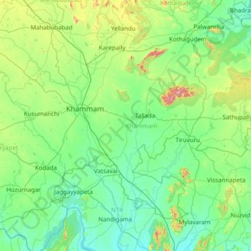
Name: Khammam topographic map, elevation, terrain.
Location: Khammam, Telangana, India (16.76757 79.80125 17.57790 80.92558)
Average elevation: 430 ft
Minimum elevation: 79 ft
Maximum elevation: 2,539 ft
Make a donation
Gear up for your next adventure:
As an Amazon Associate, this site earns from qualifying purchases at no extra cost to you.
Other topographic maps
Click on a map to view its topography, its elevation and its terrain.
Make a donation
Gear up for your next adventure:
As an Amazon Associate, this site earns from qualifying purchases at no extra cost to you.
Kohir
India > Telangana > Kohir mandal
Kohir is located at 17°36′00″N 77°43′00″E / 17.6000°N 77.7167°E / 17.6000; 77.7167. It has an average elevation of 627 metres (2060 ft). It is 100 km from Hyderabad, 53 km from Bidar and 21 km from Zaheerabad.
Average elevation: 2,080 ft
ChengiCherla Cheruvu aka Pochamma Kunta
India > Telangana > Medipally mandal > Chengicherla
Average elevation: 1,673 ft
Adilabad
India > Telangana > Adilabad Urban Mandal
Adilabad has an average elevation of 264 metres. The district shares its boundaries with Nirmal districts of Telangana to the south, Komaram Bheem district on the east, with Nanded on the west and Yavatmal and Chandrapur districts of Maharashtra to the north.
Average elevation: 1,017 ft
Make a donation
Gear up for your next adventure:
As an Amazon Associate, this site earns from qualifying purchases at no extra cost to you.
Make a donation
Gear up for your next adventure:
As an Amazon Associate, this site earns from qualifying purchases at no extra cost to you.
Make a donation
Gear up for your next adventure:
As an Amazon Associate, this site earns from qualifying purchases at no extra cost to you.
Make a donation
Gear up for your next adventure:
As an Amazon Associate, this site earns from qualifying purchases at no extra cost to you.
Make a donation
Gear up for your next adventure:
As an Amazon Associate, this site earns from qualifying purchases at no extra cost to you.
Make a donation
Gear up for your next adventure:
As an Amazon Associate, this site earns from qualifying purchases at no extra cost to you.
Make a donation
Gear up for your next adventure:
As an Amazon Associate, this site earns from qualifying purchases at no extra cost to you.
Make a donation
Gear up for your next adventure:
As an Amazon Associate, this site earns from qualifying purchases at no extra cost to you.
Make a donation
Gear up for your next adventure:
As an Amazon Associate, this site earns from qualifying purchases at no extra cost to you.
Make a donation
Gear up for your next adventure:
As an Amazon Associate, this site earns from qualifying purchases at no extra cost to you.
Make a donation
Gear up for your next adventure:
As an Amazon Associate, this site earns from qualifying purchases at no extra cost to you.
Make a donation
Gear up for your next adventure:
As an Amazon Associate, this site earns from qualifying purchases at no extra cost to you.
Sadashivanagar lake
India > Telangana > Sadashivnagar mandal > Sadashivnagar
Average elevation: 1,791 ft
Make a donation
Gear up for your next adventure:
As an Amazon Associate, this site earns from qualifying purchases at no extra cost to you.
Make a donation
Gear up for your next adventure:
As an Amazon Associate, this site earns from qualifying purchases at no extra cost to you.
Make a donation
Gear up for your next adventure:
As an Amazon Associate, this site earns from qualifying purchases at no extra cost to you.
Make a donation
Gear up for your next adventure:
As an Amazon Associate, this site earns from qualifying purchases at no extra cost to you.
Make a donation
Gear up for your next adventure:
As an Amazon Associate, this site earns from qualifying purchases at no extra cost to you.
Make a donation
Gear up for your next adventure:
As an Amazon Associate, this site earns from qualifying purchases at no extra cost to you.
Make a donation
Gear up for your next adventure:
As an Amazon Associate, this site earns from qualifying purchases at no extra cost to you.
Sadasivpet
India > Telangana > Sadasivpet mandal
Sadashivpet is located at 17°37′00″N 77°57′00″E / 17.6167°N 77.9500°E / 17.6167; 77.9500. It has an average elevation of 534 meters (1755 feet). From Sadashivpet to Hyderabad 65 km, Vikarabad 36 km, Sadashivpet Road Railway Station 18 km, Bidar 69 km, Zahirabad 36 km, Gulbarga 154 km, SangaReddy 20 km.
Average elevation: 1,765 ft
Make a donation
Gear up for your next adventure:
As an Amazon Associate, this site earns from qualifying purchases at no extra cost to you.
Make a donation
Gear up for your next adventure:
As an Amazon Associate, this site earns from qualifying purchases at no extra cost to you.
Make a donation
Gear up for your next adventure:
As an Amazon Associate, this site earns from qualifying purchases at no extra cost to you.
Make a donation
Gear up for your next adventure:
As an Amazon Associate, this site earns from qualifying purchases at no extra cost to you.
Make a donation
Gear up for your next adventure:
As an Amazon Associate, this site earns from qualifying purchases at no extra cost to you.