Geolocate

Kasarani topographic map

Click on the map to display elevation.

About this map

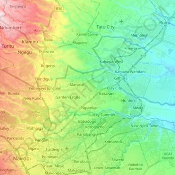
Name: Kasarani topographic map, elevation, terrain.

Location: Kasarani, Nairobi County, Nairobi, Kenya (-1.26437 36.83184 -1.16067 37.00706)

Average elevation: 5,308 ft

Minimum elevation: 4,931 ft

Maximum elevation: 6,050 ft

Other topographic maps

Click on a map to view its topography, its elevation and its terrain.

Nairobi Dam

Kenya > Nairobi County > Nairobi

Average elevation: 5,561 ft

Githurai

Kenya > Nairobi County

Average elevation: 5,059 ft

Ruaraka

Kenya > Nairobi County > Nairobi

Average elevation: 5,302 ft

Soweto West

Kenya > Nairobi County

Average elevation: 5,784 ft

Lake

Kenya > Nairobi County > Nairobi

Average elevation: 6,135 ft

Kagondo

Kenya > Nairobi County > Nairobi

Average elevation: 6,224 ft

Gear up for your next adventure:

🧭Compass with Lanyard - Easy‑carry compass for navigation
🪶Survival Guide Book - Expert advice for emergency preparedness
☀️Outdoor Sunscreen - High protection sunscreen for outdoor activities
🧭Pro Hiking Compasses - High-accuracy liquid-filled compasses for topographic orientation
🔌USB Car Charger - Car charger for on‑the‑go power needs

As an Amazon Associate, this site earns from qualifying purchases at no extra cost to you.