
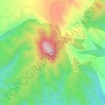
九嵕山 topographic map
Interactive map
Click on the map to display elevation.
About this map
Name: 九嵕山 topographic map, elevation, terrain.
Location: 九嵕山, 咸阳市, 陕西省, 中国 (34.62841 108.48345 34.62851 108.48355)
Average elevation: 3,074 ft
Minimum elevation: 2,438 ft
Maximum elevation: 3,973 ft
九嵕山位於中國中西部的陕西省,咸陽市禮泉縣東北22公里,山峰海拔1,188米,山勢突兀,峰巒挺拔,溝壑縱橫,山環水繞,有涇水環繞其後,渭水縈帶其前,南隔關中平原,與太白、終南諸峰遙相對峙。一般当地人默认指的是唐朝李世民的陵墓。
Other topographic maps
Click on a map to view its topography, its elevation and its terrain.