
Make a donation
Gear up for your next adventure:
As an Amazon Associate, this site earns from qualifying purchases at no extra cost to you.
Cappella Maggiore topographic map
Click on the map to display elevation.
Make a donation
Gear up for your next adventure:
As an Amazon Associate, this site earns from qualifying purchases at no extra cost to you.
About this map
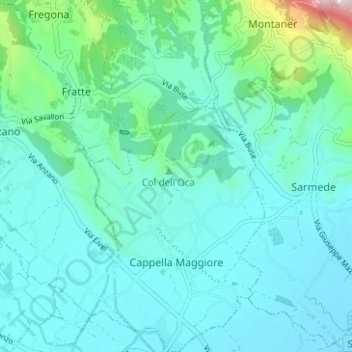
Name: Cappella Maggiore topographic map, elevation, terrain.
Location: Cappella Maggiore, Treviso, Veneto, 31012, Italia (45.95836 12.32045 46.00190 12.37739)
Average elevation: 495 ft
Minimum elevation: 236 ft
Maximum elevation: 1,946 ft
Make a donation
Gear up for your next adventure:
As an Amazon Associate, this site earns from qualifying purchases at no extra cost to you.
Other topographic maps
Click on a map to view its topography, its elevation and its terrain.
Make a donation
Gear up for your next adventure:
As an Amazon Associate, this site earns from qualifying purchases at no extra cost to you.
Make a donation
Gear up for your next adventure:
As an Amazon Associate, this site earns from qualifying purchases at no extra cost to you.
Make a donation
Gear up for your next adventure:
As an Amazon Associate, this site earns from qualifying purchases at no extra cost to you.
Monte Pizzoc
Italia > Veneto > Treviso > Fregona
Il Pizzoc è un monte delle Prealpi Trevigiane. Raggiunge i 1.565 m d'altitudine, rappresentando uno dei punti più elevati del comune di Fregona e della provincia di Treviso, a cui appartiene.
Average elevation: 4,058 ft
Make a donation
Gear up for your next adventure:
As an Amazon Associate, this site earns from qualifying purchases at no extra cost to you.
Santa Croce del Montello
Italia > Veneto > Treviso > Nervesa della Battaglia > Santa Croce del Montello
Average elevation: 440 ft
Make a donation
Gear up for your next adventure:
As an Amazon Associate, this site earns from qualifying purchases at no extra cost to you.