Geolocate

Alma topographic map

Click on the map to display elevation.

About this map

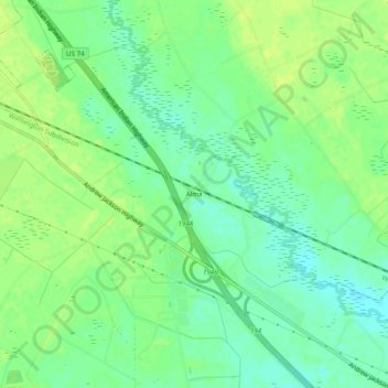
Name: Alma topographic map, elevation, terrain.

Location: Alma, Robeson County, North Carolina, 28364, United States (34.70377 -79.33254 34.74377 -79.29254)

Average elevation: 187 ft

Minimum elevation: 157 ft

Maximum elevation: 207 ft

Robeson County trails, hiking, mountain biking, running and outdoor activities

Other topographic maps

Click on a map to view its topography, its elevation and its terrain.

Rowland

United States > North Carolina > Robeson County

Average elevation: 148 ft

Prospect

United States > North Carolina > Robeson County > Prospect

Average elevation: 194 ft

McDonald

United States > North Carolina > Robeson County

Average elevation: 151 ft

Gear up for your next adventure:

🕶️GPS Smartphone Mount - Secure mount for phone navigation
🧭Hiking Compass - Precision compass for reliable navigation in the wilderness
🥾Men's Hiking Boots - Durable, waterproof footwear for rugged terrain and steep inclines
🌲Outdoor Survival Books - Best books on survival skills
🗻Climbing Gear Basics - Essential gear for beginner climbers

As an Amazon Associate, this site earns from qualifying purchases at no extra cost to you.