
Cernusco sul Naviglio topographic map
Interactive map
Click on the map to display elevation.
About this map
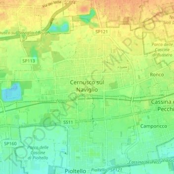
Name: Cernusco sul Naviglio topographic map, elevation, terrain.
Location: Cernusco sul Naviglio, Milan, Lombardy, 20063, Italy (45.50024 9.29928 45.54804 9.36762)
Average elevation: 440 ft
Minimum elevation: 387 ft
Maximum elevation: 495 ft
The municipality of Cernusco sul Naviglio has a total area of 13.33 km2 (5 square miles) with a median altitude of 133 metres above sea level. The municipality includes the main urban area of Cernusco and the frazione of Ronco at the eastern border of the municipal area, as well as some traditional farmhouses (cassin in Lombard) still not contiguous to other urbanized parts of the municipality.[3]
Other topographic maps
Click on a map to view its topography, its elevation and its terrain.
Mariotto
Italy > Lombardy > Milan > San Colombano al Lambro
Mariotto, San Colombano al Lambro, Milan, Lombardy, 26863, Italy
Average elevation: 203 ft
Cascina Confaloniera
Italy > Lombardy > Milan > Rosate
Cascina Confaloniera, Rosate, Unione dei Comuni I Fontanili, Milan, Lombardy, 20088, Italy
Average elevation: 351 ft
Municipio 8 di Milano
Italy > Lombardy > Milan > Milan
Municipio 8 di Milano, Milan, Lombardy, Italy
Average elevation: 453 ft
San Pietro all'Olmo
Italy > Lombardy > Milan > Cornaredo
San Pietro all'Olmo, Cornaredo, Milan, Lombardy, 20007, Italy
Average elevation: 466 ft
Vaiano Valle
Italy > Lombardy > Milan > Milan > Vaiano Valle
Vaiano Valle, Milan, Lombardy, 20139, Italy
Average elevation: 361 ft
San Colombano al Lambro
San Colombano al Lambro, Milan, Lombardy, 20078, Italy
Average elevation: 240 ft