
Hamar topographic map
Interactive map
Click on the map to display elevation.
About this map
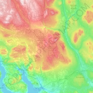
Name: Hamar topographic map, elevation, terrain.
Location: Hamar, Innlandet, Norway (60.76898 10.98098 61.23604 11.27969)
Average elevation: 1,460 ft
Minimum elevation: 394 ft
Maximum elevation: 3,360 ft
Hamar has a humid continental climate (Dfb) with fairly dry and cold winters, and comfortably warm summers. The Hamar II weather station, at an elevation of 141 metres (463 ft), started recording in 1968. The all-time high 33 °C (91 °F) was recorded in July 2018, which was the warmest month on record with average daily high 28.8 °C (83.8 °F) and mean 21.6 °C (70.9 °F). The all-time low −29.8 °C (−21.6 °F) is from in December 2010, which was a very cold month with mean −14 °C (7 °F) and average daily low −18.2 °C (−0.8 °F). A previous weather station (Hamar I, at an elevation of 139 m) recorded the coldest month on record with mean −17.2 °C (1.0 °F) in January 1917. In August 1975, the weather station "Staur Forsøksgård" in nearby Stange recorded 35 °C (95 °F).
Other topographic maps
Click on a map to view its topography, its elevation and its terrain.