Geolocate

Cayambe topographic map

Click on the map to display elevation.

About this map

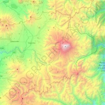
Name: Cayambe topographic map, elevation, terrain.

Location: Cayambe, Pichincha, Ecuador (-0.19557 -78.32092 0.18838 -77.83973)

Average elevation: 11,138 ft

Minimum elevation: 6,234 ft

Maximum elevation: 18,881 ft

Other topographic maps

Click on a map to view its topography, its elevation and its terrain.

San Martin

Ecuador > Pichincha > Quito Canton > Nono

Average elevation: 9,163 ft

Barrio Nuevo

Ecuador > Pichincha > Quito Canton > Nanegal

Average elevation: 5,230 ft

Nayón

Ecuador > Pichincha > Quito Canton

Average elevation: 8,520 ft

Santa Rosa

Ecuador > Pichincha > Quito Canton > Puembo

Average elevation: 7,900 ft

2 Puentes

Ecuador > Pichincha > Quito Canton > Quito

Average elevation: 9,751 ft

Volcán Cotopaxi

Ecuador > Pichincha > Machachi > Machachi

In the late 20th century, summiting Cotopaxi became a major tourist draw. The José F. Ribas Refuge (Refugio José Félix Ribas) was built in 1971 at an elevation of 4,864 m (15,960 ft) and enlarged in 2005.

Average elevation: 16,473 ft

Santa Lucia

Ecuador > Pichincha > Quito > Nanegal > Santa Lucia

Average elevation: 5,354 ft

Puéllaro

Ecuador > Pichincha > Quito Canton > Puéllaro

Average elevation: 7,011 ft

La Delicia

Ecuador > Pichincha > Quito Canton > San Felipe

Average elevation: 8,907 ft

Tanda

Ecuador > Pichincha > Quito Canton

Average elevation: 8,176 ft

Hacienda La Florida

Ecuador > Pichincha > Machachi > Aloag

Average elevation: 9,065 ft

Gear up for your next adventure:

📻Weather Alert Radios - Stay informed of storm risks while off-the-grid
📷Action Cameras - Rugged cameras to document your journeys across rugged terrain
🚑Emergency Bivvies - Heat-reflective sleeping bags for survival situations
🧤Hiking Gloves - Protective gloves for rugged trails
🌎3D Topographic Globes - Raised relief globes for a tactile understanding of geography

As an Amazon Associate, this site earns from qualifying purchases at no extra cost to you.