
Fullarton topographic map
Click on the map to display elevation.
About this map
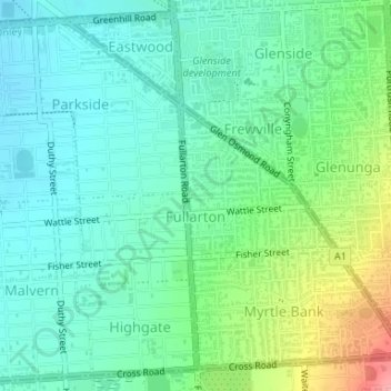
Name: Fullarton topographic map, elevation, terrain.
Location: Fullarton, South Australia, 5063, Australia (-34.95891 138.61623 -34.94631 138.63814)
Average elevation: 256 ft
Minimum elevation: 157 ft
Maximum elevation: 515 ft
Other topographic maps
Click on a map to view its topography, its elevation and its terrain.
Adelaide
Australia > South Australia > Adelaide
Adelaide is north of the Fleurieu Peninsula, on the Adelaide Plains between the Gulf St Vincent and the low-lying Mount Lofty Ranges. The city stretches 20 km (12 mi) from the coast to the foothills, and 90 km (56 mi) from Gawler at its northern extent to Sellicks Beach in the south. According to the Regional…
Average elevation: 486 ft
Port Neill
Matthew Flinders sailed past on 7 March 1802 and reported 'low front land, somewhat sandy, with raised land inland and of a barren appearance, its elevation diminishing to the northward.' The first land-based European exploration took place in April 1840, when the party of Governor Gawler, John Hill, and…
Average elevation: 30 ft
Flinders Ranges
Australia > South Australia > Pastoral Unincorporated Area
Average elevation: 2,651 ft
Mount Compass
Australia > South Australia > Alexandrina Council > Mount Compass
Average elevation: 902 ft
Happy Valley Reservior
Australia > South Australia > City of Onkaparinga > Adelaide
Average elevation: 568 ft
Victoria Square
Australia > South Australia > Adelaide City Council > Adelaide
Average elevation: 154 ft
Dullingari
Australia > South Australia > Pastoral Unincorporated Area > Innamincka
Average elevation: 292 ft
Bookabourdie Waterhole
Australia > South Australia > Pastoral Unincorporated Area > Innamincka
Average elevation: 144 ft
Stokes Hill Lookout
Australia > South Australia > Pastoral Unincorporated Area
Average elevation: 2,244 ft
Nullabor Plain
Australia > South Australia > Pastoral Unincorporated Area
One theory is that the whole area was uplifted by crustal movements in the Miocene, and since then, erosion by wind and rain has reduced its thickness. The plain has most likely never had any major defining topographic features, resulting in the extremely flat terrain across the plain today.
Average elevation: 384 ft
Kingston On Murray
Australia > South Australia > The District Council of Loxton Waikerie > Kingston On Murray
Average elevation: 95 ft
Campbelltown Re-Vegitation Community Reserve
Australia > South Australia > Adelaide
Average elevation: 299 ft
Marne River Mouth
Australia > South Australia > Mid Murray Council > Wongulla
Average elevation: 105 ft
Leigh Creek
Australia > South Australia > Pastoral Unincorporated Area > Leigh Creek
Average elevation: 876 ft
Lyndhurst
Australia > South Australia > Pastoral Unincorporated Area > Lyndhurst
Average elevation: 436 ft
Carrapateena Hill
Australia > South Australia > Pastoral Unincorporated Area
Average elevation: 492 ft
Port Noarlunga Reef Sanctuary Zone
Australia > South Australia > City of Onkaparinga > Adelaide
Average elevation: 3 ft
Adelaide (Sellicks Hill) Weather Radar
Australia > South Australia > City of Onkaparinga > Adelaide
Average elevation: 955 ft
Blue Lake
Australia > South Australia > Mount Gambier
Each November, the lake turns to a deep turquoise colour, gradually returning to a duller blue colour in late February to March. The exact cause of this phenomenon is still a matter of conjecture, but likely it involves the warming of the surface layers of the lake during the summer to around 20 °C (68 °F),…
Average elevation: 174 ft
Myponga River
Australia > South Australia > The District Council of Yankalilla > Myponga > Myponga Beach
Average elevation: 453 ft
Kalumunda Forest Reserve
Australia > South Australia > The District Council of Yankalilla
Average elevation: 869 ft
Shallow Lagoon
Australia > South Australia > Yorke Peninsula Council > Minlaton
Average elevation: 253 ft
Lake Bonney Riverland
Australia > South Australia > The Berri Barmera Council > Barmera
Average elevation: 52 ft
Marble Hill
Australia > South Australia > Anangu Pitjantjatjara Yankunytjatjara
Average elevation: 1,575 ft
Flagstaff Hill
Australia > South Australia > The District Council of Loxton Waikerie
Average elevation: 89 ft