
Make a donation
Gear up for your next adventure:
As an Amazon Associate, this site earns from qualifying purchases at no extra cost to you.
Aix-les-Bains topographic map
Click on the map to display elevation.
Make a donation
Gear up for your next adventure:
As an Amazon Associate, this site earns from qualifying purchases at no extra cost to you.
Aix-les-Bains
Aix-Les-Bains is located in the southeast of France, 107 kilometres (66 mi) east of Lyon. The town is located in a corridor between the mountain of Mont Revard, the first natural rampart of the Massif des Bauges to the east and the Lac du Bourget, the largest natural lake of France to the west. Thus, the city extends mostly on a north–south axis. Its extension is such that its agglomeration merges gradually with that of Chambéry. The area of the commune is 12.62 square kilometres (4.87 sq mi), which is large for the department. The town is traditionally divided into two, the lower town that occupies the banks of the lake to the west and the upper town, where the town centre is located, overlooking the Lac du Bourget. The town was first built on the heights in order to avoid the many floods of the lake until it was regulated by the dam of the Compagnie Nationale du Rhône (CNR) between the Rhône and the natural spillway of lake, the Canal de Savières. The average altitude of the city is about 320 metres (1,050 ft) while the lower part of it is only around 224 metres (735 ft), at the level of the lake.
Make a donation
Gear up for your next adventure:
As an Amazon Associate, this site earns from qualifying purchases at no extra cost to you.
About this map
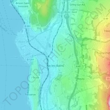
Name: Aix-les-Bains topographic map, elevation, terrain.
Average elevation: 1,142 ft
Minimum elevation: 745 ft
Maximum elevation: 2,943 ft
Make a donation
Gear up for your next adventure:
As an Amazon Associate, this site earns from qualifying purchases at no extra cost to you.
Other topographic maps
Click on a map to view its topography, its elevation and its terrain.
Mollard Durand
France > Auvergne-Rhône-Alpes > Savoy > Saint-Martin-de-la-Porte
Average elevation: 3,445 ft
Les Ménuires
France > Auvergne-Rhône-Alpes > Savoy
The resort was founded in 1964 and has an altitude range of 1,850 m (6,070 ft).
Average elevation: 6,768 ft
Make a donation
Gear up for your next adventure:
As an Amazon Associate, this site earns from qualifying purchases at no extra cost to you.
Le Charvet
France > Auvergne-Rhône-Alpes > Savoy > Bourg-Saint-Maurice > Arc 1800
Average elevation: 5,417 ft
Make a donation
Gear up for your next adventure:
As an Amazon Associate, this site earns from qualifying purchases at no extra cost to you.
Le Désert d'Entremont
France > Auvergne-Rhône-Alpes > Savoy > Entremont-le-Vieux
Average elevation: 3,809 ft
La Ville des Glaciers
France > Auvergne-Rhône-Alpes > Savoy > Bourg-Saint-Maurice
Average elevation: 7,152 ft
Le Grand Couloir
France > Auvergne-Rhône-Alpes > Savoy > Pralognan-la-Vanoise
Average elevation: 6,155 ft
Make a donation
Gear up for your next adventure:
As an Amazon Associate, this site earns from qualifying purchases at no extra cost to you.
Make a donation
Gear up for your next adventure:
As an Amazon Associate, this site earns from qualifying purchases at no extra cost to you.
Make a donation
Gear up for your next adventure:
As an Amazon Associate, this site earns from qualifying purchases at no extra cost to you.
La Chiserette
France > Auvergne-Rhône-Alpes > Savoy > Champagny-en-Vanoise
Average elevation: 6,329 ft
Make a donation
Gear up for your next adventure:
As an Amazon Associate, this site earns from qualifying purchases at no extra cost to you.
Dou des Ponts
France > Auvergne-Rhône-Alpes > Savoy > Pralognan-la-Vanoise
Average elevation: 6,243 ft
Make a donation
Gear up for your next adventure:
As an Amazon Associate, this site earns from qualifying purchases at no extra cost to you.
Le Laisonnay d'En Bas
France > Auvergne-Rhône-Alpes > Savoy > Champagny-en-Vanoise
Average elevation: 7,021 ft
Make a donation
Gear up for your next adventure:
As an Amazon Associate, this site earns from qualifying purchases at no extra cost to you.