
Bee Cave topographic map
Click on the map to display elevation.
Bee Cave
According to the United States Census Bureau in 2010, the city has a total area of 2.6 square miles (6.7 km2), all of it land. Prior to the 2010 census, Bee Cave went from being a village to being a city, increasing its area to 6.8 square miles (18 km2), all land. It borders Lakeway to the northwest. The landscape of Bee Cave is generally hilly, with elevations ranging from 875 to 1025 feet (265–310 m).
About this map
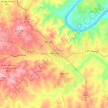
Name: Bee Cave topographic map, elevation, terrain.
Location: Bee Cave, Travis County, Texas, United States (30.28614 -98.00369 30.32981 -97.90868)
Average elevation: 886 ft
Minimum elevation: 486 ft
Maximum elevation: 1,191 ft
Travis County trails, hiking, mountain biking, running and outdoor activities
Other topographic maps
Click on a map to view its topography, its elevation and its terrain.
Roy G. Guerrero Colorado River Metro Park
United States > Texas > Travis County > Austin
Average elevation: 463 ft
Austin
United States > Texas > Travis County > Austin
The elevation of Austin varies from 425 feet (130 m) to approximately 1,000 feet (305 m) above sea level. Due to the fact it straddles the Balcones Fault, much of the eastern part of the city is flat, with heavy clay and loam soils, whereas the western part and western suburbs consist of rolling hills on the…
Average elevation: 666 ft
Pflugerville
United States > Texas > Travis County > Pflugerville > Pflugerville
Average elevation: 719 ft