
Clear Creek Estates topographic map
Interactive map
Click on the map to display elevation.
About this map
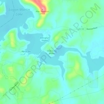
Name: Clear Creek Estates topographic map, elevation, terrain.
Average elevation: 522 ft
Minimum elevation: 449 ft
Maximum elevation: 794 ft
Other topographic maps
Click on a map to view its topography, its elevation and its terrain.
Talladega
United States > Alabama > Talladega County
Talladega, Talladega County, Alabama, United States
Average elevation: 627 ft
Mignon
United States > Alabama > Talladega County
Mignon, Talladega County, Alabama, 35150, United States
Average elevation: 564 ft
The Moon
United States > Alabama > Talladega County > Sylacauga
The Moon, Sylacauga, Talladega County, Alabama, 35150, United States
Average elevation: 653 ft
Echo Hills
United States > Alabama > Talladega County > Lincoln
Echo Hills, Lincoln, Talladega County, Alabama, 35096, United States
Average elevation: 564 ft
Fayetteville
United States > Alabama > Talladega County
Fayetteville, Talladega County, Alabama, United States
Average elevation: 476 ft
Oxford
United States > Alabama > Talladega County
Oxford, Talladega County, Alabama, United States
Average elevation: 646 ft
Sylacauga
United States > Alabama > Talladega County
Sylacauga, Talladega County, Alabama, United States
Average elevation: 636 ft
Lincoln
United States > Alabama > Talladega County
Lincoln, Talladega County, Alabama, United States
Average elevation: 554 ft
Oxford
United States > Alabama > Talladega County > Oxford
Oxford, Talladega County, Alabama, United States
Average elevation: 607 ft
Colony
United States > Alabama > Talladega County > Lincoln
Colony, Lincoln, Talladega County, Alabama, United States
Average elevation: 495 ft
Childersburg
United States > Alabama > Talladega County
Childersburg, Talladega County, Alabama, United States
Average elevation: 479 ft
Sand Mountain
United States > Alabama > Talladega County
Sand Mountain, Talladega County, Alabama, 35161, United States
Average elevation: 663 ft
Alpine Bay
United States > Alabama > Talladega County > Alpine Bay
Alpine Bay, Talladega County, Alabama, United States
Average elevation: 518 ft
Sylacauga
United States > Alabama > Talladega County > Sylacauga > Sylacauga
Sylacauga, Talladega County, Alabama, 35150, United States
Average elevation: 620 ft
Sherwood Shores
United States > Alabama > Talladega County > Sherwood Shores
Sherwood Shores, Talladega County, Alabama, 35131, United States
Average elevation: 502 ft