
Make a donation
Gear up for your next adventure:
As an Amazon Associate, this site earns from qualifying purchases at no extra cost to you.
Bas-Saint-Laurent topographic map
Click on the map to display elevation.
Make a donation
Gear up for your next adventure:
As an Amazon Associate, this site earns from qualifying purchases at no extra cost to you.
Bas-Saint-Laurent
The topography of Bas-Saint-Laurent has two main elements : the plateaus of the Appalachian Mountains, called Notre Dame Mountains, and the lowlands in the fine stripe of land along the Saint Lawrence river. These are separated by an intermediate area of ridges and foothills which meld with the plateaus. The Notre Dame Mountains, are a group of small mountains with summits reaching between 600 and 700 m (2,000 and 2,300 ft) high. the landscape is sometimes interrupted by valleys, like the Témiscouata valley or Matapedia Valley. These two parallel valleys allow access to The Maritimes, Maine and Chaleur Bay.
Make a donation
Gear up for your next adventure:
As an Amazon Associate, this site earns from qualifying purchases at no extra cost to you.
About this map
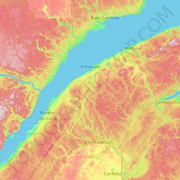
Name: Bas-Saint-Laurent topographic map, elevation, terrain.
Location: Bas-Saint-Laurent, Quebec, Canada (47.06672 -70.20334 49.18906 -65.94841)
Average elevation: 935 ft
Minimum elevation: -3 ft
Maximum elevation: 3,455 ft
Make a donation
Gear up for your next adventure:
As an Amazon Associate, this site earns from qualifying purchases at no extra cost to you.
Other topographic maps
Click on a map to view its topography, its elevation and its terrain.
Mount Royal
Canada > Quebec > Urban agglomeration of Montreal > Montreal
The hill is part of the Monteregian Hills situated between the Laurentians and the Appalachian Mountains. It gave its Latin name, Mons Regius, to the Monteregian chain. The hill consists of three peaks: Colline de la Croix (or Mont Royal proper) at 233 m (764 ft), Colline d'Outremont (or Mount Murray, in the…
Average elevation: 364 ft
Mount Royal Park
Canada > Quebec > Urban agglomeration of Montreal > Montreal
The mountain is part of the Monteregian Hills situated between the Laurentians and the Appalachian Mountains. It gave its Latin name, Mons Regius, to the Monteregian chain. The mountain consists of three peaks: Colline de la Croix (or Mont Royal proper) at 233 m (764 ft), Colline d'Outremont (or Mount Murray,…
Average elevation: 361 ft
Make a donation
Gear up for your next adventure:
As an Amazon Associate, this site earns from qualifying purchases at no extra cost to you.
Make a donation
Gear up for your next adventure:
As an Amazon Associate, this site earns from qualifying purchases at no extra cost to you.
Grande-Cascapédia
Canada > Quebec > Bonaventure (MRC) > Cascapédia-Saint-Jules
Average elevation: 157 ft
Make a donation
Gear up for your next adventure:
As an Amazon Associate, this site earns from qualifying purchases at no extra cost to you.
Quebec
Canada > Quebec > Urban agglomeration of Québec
Quebec City was built on the north bank of the Saint Lawrence River, where it narrows and meets the mouth of the Saint-Charles River. Old Quebec is located on top and at the foot of Cap-Diamant, which is on the eastern edge of a plateau called the promontory of Quebec (Quebec hill). Because of this topographic…
Average elevation: 328 ft
Make a donation
Gear up for your next adventure:
As an Amazon Associate, this site earns from qualifying purchases at no extra cost to you.
Make a donation
Gear up for your next adventure:
As an Amazon Associate, this site earns from qualifying purchases at no extra cost to you.
Make a donation
Gear up for your next adventure:
As an Amazon Associate, this site earns from qualifying purchases at no extra cost to you.
Galerie d'amenée d'eau, Manic-5
Canada > Quebec > Manicouagan > Rivière-aux-Outardes
Average elevation: 1,112 ft
Make a donation
Gear up for your next adventure:
As an Amazon Associate, this site earns from qualifying purchases at no extra cost to you.
Make a donation
Gear up for your next adventure:
As an Amazon Associate, this site earns from qualifying purchases at no extra cost to you.
Make a donation
Gear up for your next adventure:
As an Amazon Associate, this site earns from qualifying purchases at no extra cost to you.
Saint-Adolphe
Canada > Quebec > La Jacques-Cartier > Stoneham-et-Tewkesbury > Saint-Adolphe
Average elevation: 1,572 ft
Make a donation
Gear up for your next adventure:
As an Amazon Associate, this site earns from qualifying purchases at no extra cost to you.
Club de Plein Air Saint Adolphe d'Howard
Canada > Quebec > Les Pays-d'en-Haut > Saint-Adolphe-d'Howard
Average elevation: 1,309 ft
Make a donation
Gear up for your next adventure:
As an Amazon Associate, this site earns from qualifying purchases at no extra cost to you.
Make a donation
Gear up for your next adventure:
As an Amazon Associate, this site earns from qualifying purchases at no extra cost to you.
Hemmingford
Canada > Quebec > Les Jardins-de-Napierville > Hemmingford (village)
Average elevation: 233 ft
Make a donation
Gear up for your next adventure:
As an Amazon Associate, this site earns from qualifying purchases at no extra cost to you.
Parc Marie-Claire-Kirkland-Casgrain
Canada > Quebec > Urban agglomeration of Montreal > Montreal
Average elevation: 79 ft