Geolocate

Farris topographic map

Click on the map to display elevation.

About this map

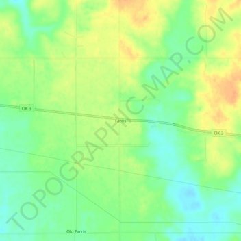
Name: Farris topographic map, elevation, terrain.

Location: Farris, Atoka County, Oklahoma, United States (34.24238 -95.88636 34.28238 -95.84636)

Average elevation: 535 ft

Minimum elevation: 479 ft

Maximum elevation: 594 ft

Atoka County trails, hiking, mountain biking, running and outdoor activities

Other topographic maps

Click on a map to view its topography, its elevation and its terrain.

Atoka

United States > Oklahoma > Atoka County

Average elevation: 604 ft

Caney

United States > Oklahoma > Atoka County

Average elevation: 554 ft

Tushka

United States > Oklahoma > Atoka County

Average elevation: 617 ft

Stringtown

United States > Oklahoma > Atoka County

Average elevation: 646 ft

Gear up for your next adventure:

🪶Fire Starter Kit - Reliable fire starter for survival and camping
🥾Men's Hiking Boots - Durable, waterproof footwear for rugged terrain and steep inclines
Camping Coffee Makers - Enjoy premium coffee at the summit or campsite
🪵Folding Camp Saw - Compact saw for wood and campsite work
🥤Water Filter Bottle - All‑in‑one filter bottle for safe hydration

As an Amazon Associate, this site earns from qualifying purchases at no extra cost to you.