
Make a donation
Gear up for your next adventure:
As an Amazon Associate, this site earns from qualifying purchases at no extra cost to you.
Champasak Province topographic map
Click on the map to display elevation.
Make a donation
Gear up for your next adventure:
As an Amazon Associate, this site earns from qualifying purchases at no extra cost to you.
Champasak Province
The Mekong Channel from Phou Xiang Thong to Siphandon Important Bird Area (IBA) is 34,200 ha (85,000 acres) in size. A portion of the IBA (10,000 hectares) overlaps with the 120,000 ha (300,000 acres) Phou Xieng Thong National Protected Area. The IBA encompasses two provinces, Champasak and Salavan. The IBA is at an elevation of 40–50 m (130–160 ft). Its topography consists of earth banks, rocky banks, rocky islands, sandbars, low vegetated islands, rocky islets, and sandy beaches. Notable avifauna include Laos's last known nesting little terns, river lapwings, river terns, small pratincoles and wire-tailed swallows.
Make a donation
Gear up for your next adventure:
As an Amazon Associate, this site earns from qualifying purchases at no extra cost to you.
About this map
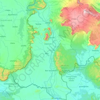
Name: Champasak Province topographic map, elevation, terrain.
Location: Champasak Province, Laos (13.90968 105.20523 15.47013 106.82819)
Average elevation: 860 ft
Minimum elevation: 157 ft
Maximum elevation: 5,427 ft
Make a donation
Gear up for your next adventure:
As an Amazon Associate, this site earns from qualifying purchases at no extra cost to you.
Other topographic maps
Click on a map to view its topography, its elevation and its terrain.
B. Saylom
Laos > Vientiane Prefecture > Chanthabuly District > Vientiane Capital
Average elevation: 561 ft
Make a donation
Gear up for your next adventure:
As an Amazon Associate, this site earns from qualifying purchases at no extra cost to you.
Chommanytai
Laos > Vientiane Prefecture > Xaysetha District > Vientiane Capital
Average elevation: 564 ft
Make a donation
Gear up for your next adventure:
As an Amazon Associate, this site earns from qualifying purchases at no extra cost to you.
Make a donation
Gear up for your next adventure:
As an Amazon Associate, this site earns from qualifying purchases at no extra cost to you.
Make a donation
Gear up for your next adventure:
As an Amazon Associate, this site earns from qualifying purchases at no extra cost to you.