Geolocate

Bertram topographic map

Click on the map to display elevation.

About this map

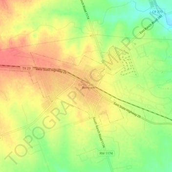
Name: Bertram topographic map, elevation, terrain.

Location: Bertram, Burnet County, Texas, United States (30.73421 -98.08526 30.75270 -98.03934)

Average elevation: 1,220 ft

Minimum elevation: 1,106 ft

Maximum elevation: 1,306 ft

Burnet County trails, hiking, mountain biking, running and outdoor activities

Other topographic maps

Click on a map to view its topography, its elevation and its terrain.

Joppa

United States > Texas > Burnet County

Average elevation: 1,122 ft

Naruna

United States > Texas > Burnet County

Average elevation: 1,460 ft

Spider Mountain

United States > Texas > Burnet County

Average elevation: 1,122 ft

Bertram

United States > Texas > Burnet County > Bertram > Bertram

Average elevation: 1,220 ft

Rocky Point

United States > Texas > Burnet County

Average elevation: 1,056 ft

Gear up for your next adventure:

🔪Outdoor Multitools - Essential survival tools for gear repair and field use
🗺️NatGeo Topo Maps - High-quality waterproof printed topographic maps of US Parks
🌡️Portable Weather Meter - Track weather conditions on the trail
💧Water Filtration Bottles - Safely drink from streams and lakes while exploring
🪶Camp Gear Gift Set - Perfect gift bundle for outdoor fans

As an Amazon Associate, this site earns from qualifying purchases at no extra cost to you.